IMAGES TAKEN NEAR TO
Lewis Street, CAERPHILLY, CF83 8PP
Introduction
This page details the photographs taken nearby to Lewis Street, CF83 8PP by members of the Geograph project.
The Geograph project started in 2005 with the aim of publishing, organising and preserving representative images for every square kilometre of Great Britain, Ireland and the Isle of Man.

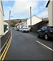
There are currently over 7.5m images from over14,400 individuals and you can help contribute to the project by visiting https://www.geograph.org.uk
Image Map
Images are licensed for reuse under creativecommons.org/licenses/by-sa/2.0
Notes
- Clicking on the map will re-center to the selected point.
- The higher the marker number, the further away the image location is from the centre of the postcode.
Image Listing (187 Images Found)
Images are licensed for reuse under creativecommons.org/licenses/by-sa/2.0
Image
Details
Distance
1
Station Street, Machen
Houses on the north side of Station Street, viewed from Church Street.
Passenger services at Machen railway station ceased in 1962.
Image: © Jaggery
Taken: 26 Feb 2011
0.03 miles
2
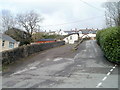
Old Station House, Machen
The view up the northern end of Church Street. The house on the right is Old Station House. Passenger services at Machen Station ceased in 1962.
To the left of the house in an arch of a railway bridge. http://www.geograph.org.uk/photo/2285731
Image: © Jaggery
Taken: 26 Feb 2011
0.03 miles
3
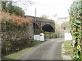
Arches of a former railway bridge, Machen
Viewed from the northern end of Church Street. The bridge is still in use, carrying Penrhiw Lane http://www.geograph.org.uk/photo/2285749 above what were formerly railway lines. The arches are at the perimeter of Old Station House. http://www.geograph.org.uk/photo/2285723
Image: © Jaggery
Taken: 26 Feb 2011
0.03 miles
4
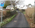
Penrhiw Lane bridge, Machen
The view north along Penrhiw Lane at the point where it crosses a bridge. Decades ago, railway lines adjacent to Machen station passed under the bridge. Passenger services at the station ceased in 1962.
Image: © Jaggery
Taken: 26 Feb 2011
0.03 miles
5
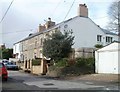
Up Lewis Street, Machen
Lewis Street ascends northwards from the A468 Commercial Road towards Pandy Lane and Wyndham Street.
Image: © Jaggery
Taken: 14 Mar 2019
0.03 miles
6
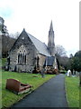
West side of St John the Baptist Church, Machen
Viewed from near the Church Street entrance. Built in the Gothic Decorated style, the church is in the Church in Wales parish of Machen, part of the benefice of Bedwas with Machen with Rudry, in the deanery of Bassaleg.
Image: © Jaggery
Taken: 26 Feb 2011
0.04 miles
7
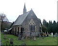
Machen church viewed from the NW
Viewed from the top end of Church Street, looking SE.
Built in the Gothic Decorated style, St John the Baptist is a Church in Wales church in the parish of Machen, part of the benefice of Bedwas with Machen with Rudry, in the deanery of Bassaleg.
Image: © Jaggery
Taken: 26 Feb 2011
0.04 miles
8
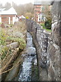
Stream, Church Street, Machen
A stream rushes noisily towards the Rhymney River, down a channel on the east side of Church Street, Machen
Image: © Jaggery
Taken: 26 Feb 2011
0.04 miles
9
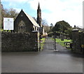
Churchyard entrance gates, Machen
The entrance to St John the Baptist churchyard from the east side of Church Street.
Image: © Jaggery
Taken: 14 Mar 2019
0.05 miles
10
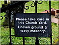
Please taken care in this Church Yard - Uneven ground & heavy masonry, Machen
The caution notice is on a churchyard entrance gate here. https://www.geograph.org.uk/photo/6090312
Image: © Jaggery
Taken: 14 Mar 2019
0.05 miles