IMAGES TAKEN NEAR TO
Waterloo Place, CAERPHILLY, CF83 8NL
Introduction
This page details the photographs taken nearby to Waterloo Place, CF83 8NL by members of the Geograph project.
The Geograph project started in 2005 with the aim of publishing, organising and preserving representative images for every square kilometre of Great Britain, Ireland and the Isle of Man.

There are currently over 7.5m images from over14,400 individuals and you can help contribute to the project by visiting https://www.geograph.org.uk
Image Map
Images are licensed for reuse under creativecommons.org/licenses/by-sa/2.0
Notes
- Clicking on the map will re-center to the selected point.
- The higher the marker number, the further away the image location is from the centre of the postcode.
Image Listing (61 Images Found)
Images are licensed for reuse under creativecommons.org/licenses/by-sa/2.0
Image
Details
Distance
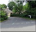
1

Waterloo Place Houses
Built on the site of Waterloo Station - a halt on the Newport to Caerphilly Railway. Uniquely, because the double track railway was split either side of the valley here, only westbound trains used this station.
Image: © John Thorn
Taken: 15 Feb 2007
0.02 miles
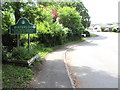
2
Waterloo Place, Waterloo
The western end of dead-end Waterloo Place viewed across the main road through Waterloo, a hamlet in Caerphilly County Borough. Old maps show Waterloo Halt railway station nearby. Waterloo Halt closed in 1956.
Image: © Jaggery
Taken: 23 May 2019
0.03 miles
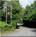
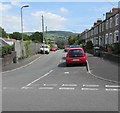
3
Waterloo - Please Drive Carefully
The road south from the A468 Newport Road reaches the northern edge of Waterloo, a hamlet in Caerphilly County Borough. The text is also in Welsh. The council's website records that the hamlet's name is derived from two streets named after the Waterloo Forge and Tinplate works which, amongst other items, made equipment for the aviation industry as there was an aircraft works nearby in Machen. The tinplate works closed in 1943.
Image: © Jaggery
Taken: 23 May 2019
0.04 miles
4
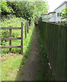
Path on the Machen Forge Trail, Waterloo
Opposite Green Meadow. https://www.geograph.org.uk/photo/6161272 Waterloo is a hamlet in Caerphilly County Borough.
Image: © Jaggery
Taken: 23 May 2019
0.04 miles
5
Rural electricity substation near Waterloo
A rural part of the Western Power Distribution electricity supply infrastructure alongside the road from the A468 to the hamlet of Waterloo in Caerphilly County Borough. The substation identifier is S/S 54-2008.
Image: © Jaggery
Taken: 23 May 2019
0.04 miles
6
Waterloo Terrace, Waterloo
Dead-end street extending for 115 metres from the northeast side
of the main road through the hamlet in Caerphilly County Borough.
Image: © Jaggery
Taken: 23 May 2019
0.05 miles
7

Waterloo bungalows
Alongside the main road through Waterloo, a hamlet in Caerphilly County Borough.
The broken white lines are at the Waterloo Terrace junction.
Image: © Jaggery
Taken: 23 May 2019
0.05 miles
8

Waterloo Terrace turning circle, Waterloo
At the northeast end of Waterloo Terrace, 115 metres from the main road through the hamlet.
Image: © Jaggery
Taken: 23 May 2019
0.05 miles
9
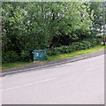
Shades of green in Waterloo
A dark green Wales & West Utilities gas installation is alongside the
main road through Waterloo, a hamlet in Caerphilly County Borough.
Image: © Jaggery
Taken: 23 May 2019
0.05 miles
10
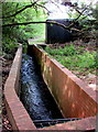
Water channel in Waterloo
On the west side of the unnamed road from the A468 to Waterloo, a hamlet in Caerphilly County Borough.
Image: © Jaggery
Taken: 23 May 2019
0.05 miles