IMAGES TAKEN NEAR TO
Cae Bach, CAERPHILLY, CF83 8NG
Introduction
This page details the photographs taken nearby to Cae Bach, CF83 8NG by members of the Geograph project.
The Geograph project started in 2005 with the aim of publishing, organising and preserving representative images for every square kilometre of Great Britain, Ireland and the Isle of Man.

There are currently over 7.5m images from over14,400 individuals and you can help contribute to the project by visiting https://www.geograph.org.uk
Image Map
Images are licensed for reuse under creativecommons.org/licenses/by-sa/2.0
Notes
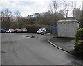
- Clicking on the map will re-center to the selected point.
- The higher the marker number, the further away the image location is from the centre of the postcode.
Image Listing (63 Images Found)
Images are licensed for reuse under creativecommons.org/licenses/by-sa/2.0
Image
Details
Distance
1
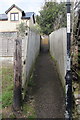
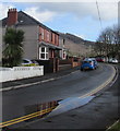
Fenced path from the north side of Riverside Terrace, Machen
Path towards Cae Bach and Ffwrwm Road.
Image: © Jaggery
Taken: 14 Mar 2019
0.04 miles
2
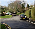
Western end of Ffwrwm Road, Machen
The Cae Bach junction is on the left.
Image: © Jaggery
Taken: 14 Mar 2019
0.04 miles
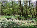
3
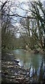
Afon Rhymni / Rhymney River, Machen Forge Trail
Machen Forge Trail is a rural walk through villages and countryside, covering the old industrial area of Machen and Waterloo.
Image: © Kev Griffin
Taken: 5 Apr 2009
0.05 miles
4
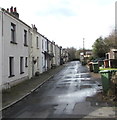
Riverside Terrace, Machen
On the north bank of the Rhymney River.
Image: © Jaggery
Taken: 14 Mar 2019
0.05 miles
5
Small puddle on Ffwrwm Road, Machen
Viewed on March 14th 2019.
Image: © Jaggery
Taken: 14 Mar 2019
0.05 miles
6
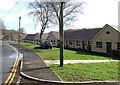
Bungalows on the south side of Ffwrwm Road, Machen
Originally, bungalow was used in English for a lightly-built house, with a veranda and one storey.
In current UK usage it is a convenient word for any one-storey dwelling.
Image: © Jaggery
Taken: 14 Mar 2019
0.07 miles
7
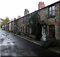
Riverside Terrace houses, Machen
On the north bank of the Rhymney River.
Image: © Jaggery
Taken: 14 Mar 2019
0.07 miles
8
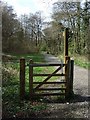
Stile off Green Row, Machen Forge Trail
Machen Forge Trail is a rural walk through villages and countryside, covering the old industrial area of Machen and Waterloo.
Image: © Kev Griffin
Taken: 5 Apr 2009
0.07 miles
9
Colliers Row electricity substation, Machen
The large grey cabinet is a Western Power Distribution electricity substation.
Its identifier is Colliers Row Machen S/S 541840.
Image: © Jaggery
Taken: 14 Mar 2019
0.10 miles
10
Lying Log, Machen Forge Trail
Machen Forge Trail is a rural walk through villages and countryside, covering the old industrial area of Machen and Waterloo.
Image: © Kev Griffin
Taken: 5 Apr 2009
0.10 miles