IMAGES TAKEN NEAR TO
Pandy Road, CAERPHILLY, CF83 8JQ
Introduction
This page details the photographs taken nearby to Pandy Road, CF83 8JQ by members of the Geograph project.
The Geograph project started in 2005 with the aim of publishing, organising and preserving representative images for every square kilometre of Great Britain, Ireland and the Isle of Man.

There are currently over 7.5m images from over14,400 individuals and you can help contribute to the project by visiting https://www.geograph.org.uk
Image Map
Images are licensed for reuse under creativecommons.org/licenses/by-sa/2.0
Notes
- Clicking on the map will re-center to the selected point.
- The higher the marker number, the further away the image location is from the centre of the postcode.
Image Listing (19 Images Found)
Images are licensed for reuse under creativecommons.org/licenses/by-sa/2.0
Image
Details
Distance

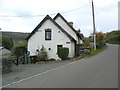
6
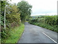
Pandy Road heads west away from Bedwas
The white line painted in the middle of the road
ends here. Pandy Road heads into the countryside.
Image: © Jaggery
Taken: 13 Aug 2011
0.16 miles
7
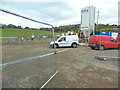
Construction site for new housing, Pandy Rd, Bedwas
Image: © John Lord
Taken: 27 Oct 2018
0.18 miles
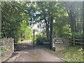
8
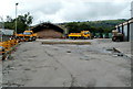
Highways Department Bedwas Depot
The Caerphilly County Borough Council site is located opposite the roundabout at the western end of Greenway, Bedwas House Industrial Estate.
Image: © Jaggery
Taken: 13 Aug 2011
0.18 miles