IMAGES TAKEN NEAR TO
Dan Y Deri, CAERPHILLY, CF83 8HR
Introduction
This page details the photographs taken nearby to Dan Y Deri, CF83 8HR by members of the Geograph project.
The Geograph project started in 2005 with the aim of publishing, organising and preserving representative images for every square kilometre of Great Britain, Ireland and the Isle of Man.

There are currently over 7.5m images from over14,400 individuals and you can help contribute to the project by visiting https://www.geograph.org.uk
Image Map
Images are licensed for reuse under creativecommons.org/licenses/by-sa/2.0
Notes
- Clicking on the map will re-center to the selected point.
- The higher the marker number, the further away the image location is from the centre of the postcode.
Image Listing (27 Images Found)
Images are licensed for reuse under creativecommons.org/licenses/by-sa/2.0
Image
Details
Distance
1
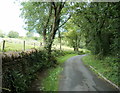
Stone wall lining Pandymawr Road, Bedwas
The stone wall on the west side of the road ends at a fence-lined farm entrance track ahead.
Image: © Jaggery
Taken: 13 Aug 2011
0.04 miles
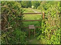
2
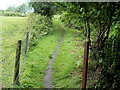
Public footpath west of Pandymawr Road, Bedwas
A track heads WNW away from Pandymawr Road south of this http://www.geograph.org.uk/photo/3135295 tunnel.
Image: © Jaggery
Taken: 13 Aug 2011
0.07 miles
3
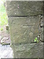
Ordnance Survey Cut Mark
This OS cut mark can be found on the NW Buttress of the Pandymawr Road Tunnel. It marks a point 89.096m above mean sea level.
Image: © Adrian Dust
Taken: 24 May 2015
0.07 miles
4
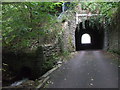
Southern entrance to tunnel under dismantled railway, Bedwas
Culvert alongside on the left.
Image: © John Lord
Taken: 12 Sep 2011
0.07 miles
5
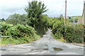
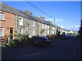
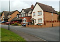
Pandymawr Road, Bedwas
Viewed from Pandy Road. Pandymawr Road heads north along the western edge of residential Bedwas.
Image: © Jaggery
Taken: 13 Aug 2011
0.08 miles
6
Northern entrance to tunnel under dismantled railway, Bedwas
Image: © John Lord
Taken: 12 Sep 2011
0.10 miles
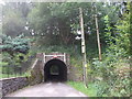
8
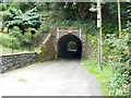
Pandymawr Road tunnel, Bedwas
A 40-metre long tunnel conveys Pandymawr Road under dismantled railway lines west of the former Bedwas railway station. http://www.geograph.org.uk/photo/1779641 A triangular sign shows that maximum headroom is 10' 3".
Image: © Jaggery
Taken: 13 Aug 2011
0.10 miles
9
Dol y Pandy houses, Bedwas
Dol y Pandy is an area of modern houses in the NW of Bedwas.
Image: © Jaggery
Taken: 13 Aug 2011
0.11 miles