IMAGES TAKEN NEAR TO
Bryn Y Fran Avenue, CAERPHILLY, CF83 8GS
Introduction
This page details the photographs taken nearby to Bryn Y Fran Avenue, CF83 8GS by members of the Geograph project.
The Geograph project started in 2005 with the aim of publishing, organising and preserving representative images for every square kilometre of Great Britain, Ireland and the Isle of Man.

There are currently over 7.5m images from over14,400 individuals and you can help contribute to the project by visiting https://www.geograph.org.uk
Image Map
Images are licensed for reuse under creativecommons.org/licenses/by-sa/2.0
Notes
- Clicking on the map will re-center to the selected point.
- The higher the marker number, the further away the image location is from the centre of the postcode.
Image Listing (133 Images Found)
Images are licensed for reuse under creativecommons.org/licenses/by-sa/2.0
Image
Details
Distance
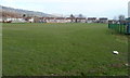
1
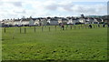
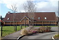
Trethomas Bluebirds AFC home pitch
The football pitch on the south side of Llanfabon Drive is the home ground of Trethomas Bluebirds Association Football Club. The club was founded in 1903.
Image: © Jaggery
Taken: 26 Feb 2011
0.03 miles
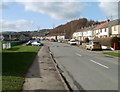
2
Houses on the east side of The Bryn, Trethomas
The road named The Bryn extends for 450 metres from Newport Road to Llanfabon Drive out of shot ahead.
This part of The Bryn is north of the Bevan Rise junction on the right. https://www.geograph.org.uk/photo/6031912
Image: © Jaggery
Taken: 24 Jan 2019
0.05 miles
3
Children's play area in Trethomas
In the northeast corner of a recreation ground which also contains a football pitch. https://www.geograph.org.uk/photo/6032313
Image: © Jaggery
Taken: 24 Jan 2019
0.06 miles
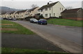
4
Bevan Rise, Trethomas
From The Bryn looking east along Bevan Rise towards Bevan Close and Bryn-y-fran Avenue.
Image: © Jaggery
Taken: 24 Jan 2019
0.07 miles
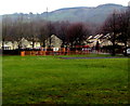
5
Bryn Field, Bedwas
A view east across the southern part of a football pitch in a recreation area known as Bryn Field.
The distant houses are in a street named The Bryn.
Image: © Jaggery
Taken: 5 Mar 2011
0.07 miles
6
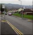
Route H bus stop, Trethomas
This stop alongside The Bryn is on bus route H from Caerphilly to Graig-y-rhacca. In January 2019, Route H is operated by Harris Coaches. The stop on the opposite side of the road is for buses to Caerphilly. Local bus routes in the Caerphilly area are indicated by a single letter. Another example is Route J from Caerphilly to Rudry. Longer distance routes are indicated by a number, such as Route 50 Caerphilly to Newport.
Image: © Jaggery
Taken: 24 Jan 2019
0.08 miles
7
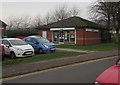
Well Pharmacy, The Bryn, Trethomas
Located near Ty Bryn Surgery. https://www.geograph.org.uk/photo/6031921
Image: © Jaggery
Taken: 24 Jan 2019
0.10 miles
8
Llanfabon Drive, Trethomas
Looking WNW from near the Navigation Street junction. On the left is an edge of a recreation area which contains a football pitch, http://www.geograph.org.uk/photo/2769512 the home venue of Trethomas Bluebirds AFC.
Image: © Jaggery
Taken: 26 Feb 2011
0.11 miles
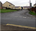
9
St Thomas Community Church, Trethomas
Church in Wales church located at the SW end of Heol-yr-ysgol. Trethomas is in the Parish of Bedwas, Diocese of Monmouth.
Image: © Jaggery
Taken: 26 Feb 2011
0.11 miles
10
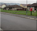
Queen Elizabeth II postbox, The Bryn, Trethomas
Alongside The Bryn, a road which extends for 450 metres from Newport Road to Llanfabon Drive.
Image: © Jaggery
Taken: 24 Jan 2019
0.12 miles