IMAGES TAKEN NEAR TO
Newport Road, CAERPHILLY, CF83 8GB
Introduction
This page details the photographs taken nearby to Newport Road, CF83 8GB by members of the Geograph project.
The Geograph project started in 2005 with the aim of publishing, organising and preserving representative images for every square kilometre of Great Britain, Ireland and the Isle of Man.

There are currently over 7.5m images from over14,400 individuals and you can help contribute to the project by visiting https://www.geograph.org.uk
Image Map
Images are licensed for reuse under creativecommons.org/licenses/by-sa/2.0
Notes
- Clicking on the map will re-center to the selected point.
- The higher the marker number, the further away the image location is from the centre of the postcode.
Image Listing (99 Images Found)
Images are licensed for reuse under creativecommons.org/licenses/by-sa/2.0
Image
Details
Distance
1
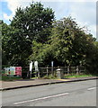
Inwardly-sloping barrier across an entrance to Riverside Park, Trethomas
The barrier on the south side of the A468 Newport Road gives walkers access
to a path into Riverside Park on the north bank of the Rhymney River.
Image: © Jaggery
Taken: 10 Aug 2018
0.04 miles
2
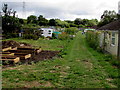
Southern edge of Trethomas Allotments
One of about 80 allotment sites in Caerphilly County Borough,
viewed through a locked gate on the east side of Lower Glyn Gwyn Street.
Image: © Jaggery
Taken: 10 Aug 2018
0.05 miles
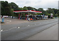
3
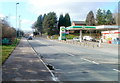
BP garage and Spar shop at the eastern boundary of Trethomas
Viewed across the A468. The Trethomas boundary sign is on the left.
Image: © Jaggery
Taken: 26 Feb 2011
0.05 miles
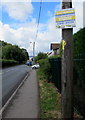
4
Cycle route 4 direction sign, Newport Road, Trethomas
The sign on a lamppost alongside the A468 Newport Road is for National Cycle Network Route 4, a long-distance route from London to Fishguard on the west coast of Wales.
Image: © Jaggery
Taken: 10 Aug 2018
0.05 miles
5
Trading Standards notice, Newport Road, Trethomas
The notice shows
NO COLD CALLING ZONE - UNINVITED TRADERS ARE NOT WELCOME HERE.
The text is also in Welsh.
Image: © Jaggery
Taken: 10 Aug 2018
0.06 miles
6
Entrance to the Esso filling station, Newport Road, Trethomas
From the A468 Newport Road. Greggs bakery and a Spar shop are at the back of the Esso filling station.
Image: © Jaggery
Taken: 10 Aug 2018
0.06 miles
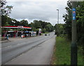
7
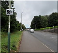
Speed camera sign facing westbound traffic on Newport Road, Trethomas
Alongside the A468 Newport Road facing traffic heading towards the centre of Trethomas.
Image: © Jaggery
Taken: 10 Aug 2018
0.07 miles
8
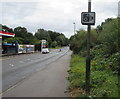
Speed camera warning sign, Newport Road, Trethomas
Facing eastbound traffic on the A468 Newport Road. An Esso filling station https://www.geograph.org.uk/photo/5977367 is on the left.
Image: © Jaggery
Taken: 10 Aug 2018
0.07 miles
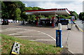
9
Esso filling station, Newport Road, Trethomas
Viewed across the A468 Newport Road in August 2018. A BP filling station was here in February 2011. http://www.geograph.org.uk/photo/2769136
Image: © Jaggery
Taken: 10 Aug 2018
0.07 miles
10
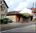
Telecoms cabinet, Lower Glyn Gwyn Street, Trethomas
On the right here https://www.geograph.org.uk/photo/2769155 the dark green BT cabinet is near the corner of Newport Road.
Image: © Jaggery
Taken: 10 Aug 2018
0.08 miles