IMAGES TAKEN NEAR TO
High Street, CAERPHILLY, CF83 8FU
Introduction
This page details the photographs taken nearby to High Street, CF83 8FU by members of the Geograph project.
The Geograph project started in 2005 with the aim of publishing, organising and preserving representative images for every square kilometre of Great Britain, Ireland and the Isle of Man.

There are currently over 7.5m images from over14,400 individuals and you can help contribute to the project by visiting https://www.geograph.org.uk
Image Map
Images are licensed for reuse under creativecommons.org/licenses/by-sa/2.0
Notes
- Clicking on the map will re-center to the selected point.
- The higher the marker number, the further away the image location is from the centre of the postcode.
Image Listing (63 Images Found)
Images are licensed for reuse under creativecommons.org/licenses/by-sa/2.0
Image
Details
Distance
1
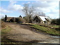
Old farm buildings, Glyn-gwyn Farm, Trethomas
The farm is in the NE corner of Trethomas.
Image: © Jaggery
Taken: 26 Feb 2011
0.03 miles
2
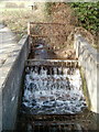
Stream enters a sink, Glyn-gwyn Farm, Trethomas
At the roadside edge of Glyn-gwyn Farm, a stream disappears underground. The feature is shown on maps as a sink.
Image: © Jaggery
Taken: 26 Feb 2011
0.03 miles
3
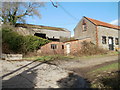
Glyn-gwyn Farm buildings, Trethomas
The farm is in the NE corner of Trethomas.
Image: © Jaggery
Taken: 26 Feb 2011
0.03 miles
4
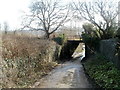
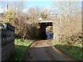
Northern side of a former railway bridge, Trethomas
The bridge, headroom 11' 0", formerly carried the Newport to Brecon railway line across the northern end of Upper Glyn Gwyn Street. Trethomas railway station was nearby. It closed in 1962.
Image: © Jaggery
Taken: 26 Feb 2011
0.03 miles
5
Southern side of a former railway bridge, Trethomas
The bridge, headroom 11' 0", formerly carried the Newport to Brecon railway line across the northern end of Upper Glyn Gwyn Street. Trethomas railway station was nearby. It closed in 1962.
Image: © Jaggery
Taken: 26 Feb 2011
0.03 miles
6
Cycle Route 4 in Trethomas 2 miles from Machen, 12 from Newport
The National Cycle Network sign points towards this https://www.geograph.org.uk/photo/5999794 former railway route at the northern edge of Trethomas. Casnewydd is Welsh for Newport.
Image: © Jaggery
Taken: 10 Aug 2018
0.04 miles
7
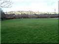
Open space on the NE edge of Trethomas
A view from the corner of Addison Way and Upper Glyn Gwyn Street at the NE edge of the residential part of Trethomas.
Image: © Jaggery
Taken: 26 Feb 2011
0.06 miles
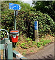
8
Headroom warning sign, Upper Glyn Gwyn Street, Trethomas
The former railway bridge https://www.geograph.org.uk/photo/2769986 in the background has headroom of 3.4 metres/11' 0".
Image: © Jaggery
Taken: 10 Aug 2018
0.06 miles
9
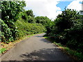
Former railway route at the northern edge of Trethomas
Looking east from Upper Glyn Gwyn Street. In 2018 this is a footpath and cycleway, part of National Cycle Network Route 4. The route used to be part of the Brecon to Newport railway line, here near the site of Trethomas station which closed in 1962.
Image: © Jaggery
Taken: 10 Aug 2018
0.06 miles
10
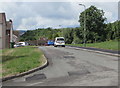
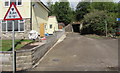
West along an unnamed side road at the northern edge of Trethomas
From Upper Glyn Gwyn Street towards William Street past the northern end of James Street.
Image: © Jaggery
Taken: 10 Aug 2018
0.07 miles