IMAGES TAKEN NEAR TO
Mountain Road, CAERPHILLY, CF83 8ER
Introduction
This page details the photographs taken nearby to Mountain Road, CF83 8ER by members of the Geograph project.
The Geograph project started in 2005 with the aim of publishing, organising and preserving representative images for every square kilometre of Great Britain, Ireland and the Isle of Man.

There are currently over 7.5m images from over14,400 individuals and you can help contribute to the project by visiting https://www.geograph.org.uk
Image Map
Images are licensed for reuse under creativecommons.org/licenses/by-sa/2.0
Notes
- Clicking on the map will re-center to the selected point.
- The higher the marker number, the further away the image location is from the centre of the postcode.
Image Listing (11 Images Found)
Images are licensed for reuse under creativecommons.org/licenses/by-sa/2.0
Image
Details
Distance
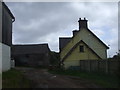
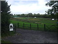
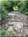
3
Mountain Road
Mountain Road goes from left to right passed this cow shed and tractor at Pen-y-waun Farm.
Image: © Rude Health
Taken: 3 Jul 2015
0.04 miles
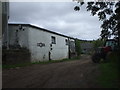
6
Free-range pigs
The Tudful herd, Pen-y-waun, Bedwas.
Image: © John Lord
Taken: 12 Sep 2011
0.10 miles
8
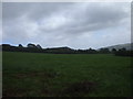
View from Mountain Rd, Pen-y-waun, Bedwas
The sharp-edged hill in the centre is a disused tip at Bedwas Colliery.
Image: © John Lord
Taken: 12 Sep 2011
0.12 miles
9
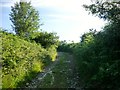
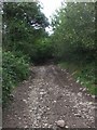
Mountain Road
Mountain Road is the bridleway that I used to walk up from Pen-y-waun Farm towards
Mynydd y Grug.
Image: © Rude Health
Taken: 3 Jul 2015
0.20 miles
10
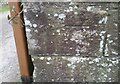
Ordnance Survey Cut Mark
This OS cut mark can be found on the stone gatepost of Llwyn Llynfa. It marks a point 159.395m above mean sea level.
Image: © Adrian Dust
Taken: 12 Feb 2021
0.22 miles