IMAGES TAKEN NEAR TO
Pandy Mawr Road, CAERPHILLY, CF83 8EQ
Introduction
This page details the photographs taken nearby to Pandy Mawr Road, CF83 8EQ by members of the Geograph project.
The Geograph project started in 2005 with the aim of publishing, organising and preserving representative images for every square kilometre of Great Britain, Ireland and the Isle of Man.

There are currently over 7.5m images from over14,400 individuals and you can help contribute to the project by visiting https://www.geograph.org.uk
Image Map
Images are licensed for reuse under creativecommons.org/licenses/by-sa/2.0
Notes
- Clicking on the map will re-center to the selected point.
- The higher the marker number, the further away the image location is from the centre of the postcode.
Image Listing (8 Images Found)
Images are licensed for reuse under creativecommons.org/licenses/by-sa/2.0
Image
Details
Distance

5
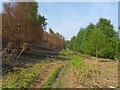
The Fire Break
A large grass fire destroyed much of the vegetation on Mynydd Dimlaith in April 2007. This footpath on the lower slopes is where the fire was stopped
Image: © Steve Sheppard
Taken: 5 May 2007
0.16 miles
6
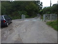
Cattle-grid on the boundary of Mynydd Dimlaith common
Image: © John Lord
Taken: 12 Sep 2011
0.18 miles
7
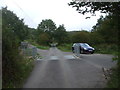
Cattle-grid on the edge of Mynydd Dimlaith common
The lack of a gate on the right rather reduces the effectiveness of the cattle-grid!
Image: © John Lord
Taken: 12 Sep 2011
0.18 miles