1
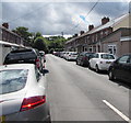
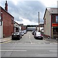
Car-lined Avenue, Trethomas
The Avenue is a dead-end street on the south side of the A468 Newport Road.
Image: © Jaggery
Taken: 10 Aug 2018
0.02 miles
2
Dearden Studio on a Trethomas corner
In October 2019 a depiction of a gigantic eye is in the window of the photographic
studio at 1 Ystrad Buildings on the corner of Newport Road and The Avenue.
Image: © Jaggery
Taken: 7 Oct 2019
0.03 miles
3
Ty-yn-y-Pwll pub, Trethomas
Newport Road pub. At the end-February 2011 date of this view, there was a For Sale (Auction) sign on the side wall.
Image: © Jaggery
Taken: 26 Feb 2011
0.03 miles
4
Trethomas War Memorial and mosaic
The War Memorial is set back from the north side of Newport Road, on the corner of Navigation Street. In front of the memorial is a circular mosaic depicting mining tools.
The War Memorial is dedicated to
THE GALLANT MEN AND WOMEN OF TRETHOMAS
WHO DIED FOR OUR FREEDOM IN THE TWO WORLD WARS
The dedication then lists the names of the 12 local people killed in the 1914-1918 war, and the 17 killed in the 1939-1945 war. The dedication ends with
WE WILL REMEMBER THEM.
https://www.geograph.org.uk/photo/5949026 to a closer view of the War Memorial.
Image: © Jaggery
Taken: 26 Feb 2011
0.03 miles
5
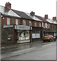
Central Buildings shops, Trethomas
The street name sign outside Mayflower Chop Suey House shows Central Buildings, which extend for about 40 metres on the south side of Newport Road (A468) from the corner of Glebe Road (at the left edge) to The Avenue.
Image: © Jaggery
Taken: 5 Mar 2011
0.03 miles
6
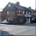
Dearden Studio, Trethomas
Photographers' premises at 1 Ystrad Buildings on the corner of Newport Road (A468) and The Avenue (though the street name sign shows only "Avenue").
Image: © Jaggery
Taken: 5 Mar 2011
0.03 miles
7
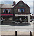
Sassykats and David Morgan, Central Buildings, Trethomas
Viewed across the A468 Newport Road. Sassykats Ink Room tattoo & body piercing shop
is next door to David Morgan ironmonger & tool merchant on the corner of The Avenue.
Image: © Jaggery
Taken: 10 Aug 2018
0.04 miles
8
East along the A468 Newport Road, Trethomas
Towards the centre of Trethomas.
Image: © Jaggery
Taken: 7 Oct 2019
0.04 miles
9
On-street parking, Glebe Road, Trethomas
Viewed across the A468 Newport Road. The Mayflower Chop Suey House https://www.geograph.org.uk/photo/5869243 is on the right.
Image: © Jaggery
Taken: 10 Aug 2018
0.04 miles
10
Village Christmas tree, Trethomas
On the north side of the A468 Newport Road viewed on January 4th 2019.
Image: © Jaggery
Taken: 4 Jan 2019
0.04 miles


