IMAGES TAKEN NEAR TO
Trethomas, CAERPHILLY, CF83 8BS
Introduction
This page details the photographs taken nearby to CF83 8BS by members of the Geograph project.
The Geograph project started in 2005 with the aim of publishing, organising and preserving representative images for every square kilometre of Great Britain, Ireland and the Isle of Man.

There are currently over 7.5m images from over14,400 individuals and you can help contribute to the project by visiting https://www.geograph.org.uk
Image Map
Images are licensed for reuse under creativecommons.org/licenses/by-sa/2.0
Notes
- Clicking on the map will re-center to the selected point.
- The higher the marker number, the further away the image location is from the centre of the postcode.
Image Listing (163 Images Found)
Images are licensed for reuse under creativecommons.org/licenses/by-sa/2.0
Image
Details
Distance
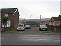
1

Central Houses, Trethomas
On the south side of the A468 Newport Road, Central Houses extend for about 50 metres from Greenacre Gardens on the right to St Margaret's Close on the left.
Image: © Jaggery
Taken: 24 Jan 2019
0.01 miles
2
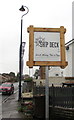
Ship Deck name sign, Trethomas
On the left here. https://www.geograph.org.uk/photo/6214152
Image: © Jaggery
Taken: 7 Oct 2019
0.02 miles
3
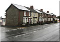
Central Houses in Trethomas
On the south side of the A468 Newport Road, Central Houses
extend from St Margaret's Close on the left to Greenacre Gardens.
Image: © Jaggery
Taken: 7 Oct 2019
0.02 miles
4
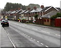
East along the A468 Newport Road, Trethomas
Towards the centre of Trethomas.
Image: © Jaggery
Taken: 7 Oct 2019
0.02 miles
5
Viviano's, Newport Road, Trethomas
Fish & chips shop on the north side of the A468 Newport Road viewed from the corner of St Margaret's Close.
Image: © Jaggery
Taken: 4 Jan 2019
0.02 miles
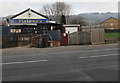
6
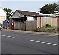
Ship Deck, Newport Road, Trethomas
Recently-opened fish & chips shop viewed in July 2019.
Viviano's https://www.geograph.org.uk/photo/6016578 was here in January 2019.
Image: © Jaggery
Taken: 17 Jul 2019
0.02 miles
7
Greenacre Gardens, Trethomas
Cul-de-sac on the south side of the A468 Newport Road.
Image: © Jaggery
Taken: 24 Jan 2019
0.02 miles
8
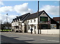
Ty-yn-y-Pwll pub, Trethomas
Newport Road pub. At the end-February 2011 date of this view, there was a For Sale (Auction) sign on the side wall.
Image: © Jaggery
Taken: 26 Feb 2011
0.03 miles
9
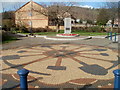
Trethomas War Memorial and mosaic
The War Memorial is set back from the north side of Newport Road, on the corner of Navigation Street. In front of the memorial is a circular mosaic depicting mining tools.
The War Memorial is dedicated to
THE GALLANT MEN AND WOMEN OF TRETHOMAS
WHO DIED FOR OUR FREEDOM IN THE TWO WORLD WARS
The dedication then lists the names of the 12 local people killed in the 1914-1918 war, and the 17 killed in the 1939-1945 war. The dedication ends with
WE WILL REMEMBER THEM.
https://www.geograph.org.uk/photo/5949026 to a closer view of the War Memorial.
Image: © Jaggery
Taken: 26 Feb 2011
0.03 miles
10
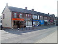
Central Buildings shops, Trethomas
The street name sign outside Mayflower Chop Suey House shows Central Buildings, which extend for about 40 metres on the south side of Newport Road (A468) from the corner of Glebe Road (at the left edge) to The Avenue.
Image: © Jaggery
Taken: 5 Mar 2011
0.03 miles