IMAGES TAKEN NEAR TO
Eglwysilan, CAERPHILLY, CF83 4JG
Introduction
This page details the photographs taken nearby to Eglwysilan, CF83 4JG by members of the Geograph project.
The Geograph project started in 2005 with the aim of publishing, organising and preserving representative images for every square kilometre of Great Britain, Ireland and the Isle of Man.

There are currently over 7.5m images from over14,400 individuals and you can help contribute to the project by visiting https://www.geograph.org.uk
Image Map
Images are licensed for reuse under creativecommons.org/licenses/by-sa/2.0
Notes
- Clicking on the map will re-center to the selected point.
- The higher the marker number, the further away the image location is from the centre of the postcode.
Image Listing (52 Images Found)
Images are licensed for reuse under creativecommons.org/licenses/by-sa/2.0
Image
Details
Distance
1
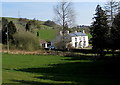
Old Rectory, Eglwysilan
Viewed from Eglwysilan Road. The former rectory is 130 metres NE of the Parish Church of St Ilan. https://www.geograph.org.uk/photo/6106412
Image: © Jaggery
Taken: 1 Apr 2019
0.00 miles
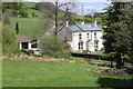
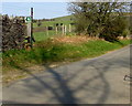
3
Entrance to the Old Rectory, Eglwysilan
From Eglwysilan Road opposite the Parish Church of St Ilan.
Image: © Jaggery
Taken: 1 Apr 2019
0.05 miles
4
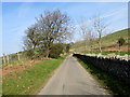
Drystone wall and deciduous trees, Eglwysilan Road, Eglwysilan
Viewed on April 1st 2019. The road here is 230 metres (755 feet) above mean sea level.
Image: © Jaggery
Taken: 1 Apr 2019
0.05 miles
5
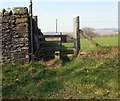
Stile on the west side of Eglwysilan Road, Eglwysilan
At the NE corner of the perimeter wall of St Ilan's churchyard,
the stile gives walkers access to a public footpath through a field.
Image: © Jaggery
Taken: 1 Apr 2019
0.06 miles
6
Public footpath direction sign, Eglwysilan Road, Eglwysilan
The green and white sign is alongside a stile https://www.geograph.org.uk/photo/6108454 giving walkers access to a public footpath through a field.
Image: © Jaggery
Taken: 1 Apr 2019
0.06 miles
7
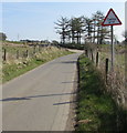
Cattle grid warning sign, Eglwysilan Road, Eglwysilan
On the western approach to this https://www.geograph.org.uk/photo/6108498 grid.
Image: © Jaggery
Taken: 1 Apr 2019
0.06 miles
8
East along Eglwysilan Road, Eglwysilan
This way for Abertridwr.
Image: © Jaggery
Taken: 1 Apr 2019
0.07 miles
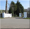
9
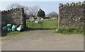
Churchyard side entrance gates, Eglwysilan Road, Eglwysilan
Giving access to the churchyard of the Parish Church of St Ilan https://www.geograph.org.uk/photo/6106412
the gates are opposite the exit from/entrance to the Old Rectory. https://www.geograph.org.uk/photo/6108424
Image: © Jaggery
Taken: 1 Apr 2019
0.07 miles
10
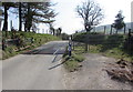
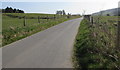
East across a cattle grid, Eglwysilan Road, Eglwysilan
Across the minor road towards Abertridwr.
Walkers can bypass the grid via the small gate.
The wider gate is for horse riders and horse-drawn vehicles.
Image: © Jaggery
Taken: 1 Apr 2019
0.07 miles