IMAGES TAKEN NEAR TO
West Side, CAERPHILLY, CF83 4HZ
Introduction
This page details the photographs taken nearby to West Side, CF83 4HZ by members of the Geograph project.
The Geograph project started in 2005 with the aim of publishing, organising and preserving representative images for every square kilometre of Great Britain, Ireland and the Isle of Man.

There are currently over 7.5m images from over14,400 individuals and you can help contribute to the project by visiting https://www.geograph.org.uk
Image Map
Images are licensed for reuse under creativecommons.org/licenses/by-sa/2.0
Notes
- Clicking on the map will re-center to the selected point.
- The higher the marker number, the further away the image location is from the centre of the postcode.
Image Listing (123 Images Found)
Images are licensed for reuse under creativecommons.org/licenses/by-sa/2.0
Image
Details
Distance
1
Leigh Social Club, Senghenydd, viewed from the north
Looking across Commercial Street.
Image: © Jaggery
Taken: 27 Apr 2012
0.02 miles
2
Leigh Social Club, Senghenydd, viewed from the south
Looking across Commercial Street.
Image: © Jaggery
Taken: 27 Apr 2012
0.02 miles
3
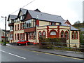
Senghenydd Community Centre
Located on Gwern Avenue. In addition to being a community centre, the building houses the Aber Valley Heritage Centre & Museum. Many of the displays relate to the mining disasters that befell this small community. 81 miners were killed in the first Universal Colliery Disaster in 1901. In 1913, a gas explosion at the colliery killed 439 miners and a rescuer.
The building opened in 1900 as Senghenydd Workmen's Hall, providing a library and reading room, public hall, and other features typical of a miners' institute of the time.
Image: © Jaggery
Taken: 27 Apr 2012
0.02 miles
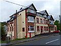
4
Aber and Senghenydd Ex-Servicemen's Club
Located on Gwern Avenue, Senghenydd.
Image: © Jaggery
Taken: 27 Apr 2012
0.02 miles
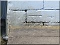
5
Ordnance Survey Cut Mark
This OS cut mark can be found on No11 Gwern Avenue. It marks a point 182.127m above mean sea level.
Image: © Adrian Dust
Taken: 25 May 2019
0.03 miles
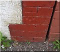
6
Ordnance Survey Cut Mark
This OS cut mark can be found on No41 Station Terrace. It marks a point 191.122m above mean sea level.
Image: © Adrian Dust
Taken: 25 May 2019
0.03 miles
7
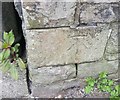
Ordnance Survey Cut Mark
This OS cut mark can be found on the SE parapet of the railway bridge. It marks a point 189.314m above mean sea level.
Image: © Adrian Dust
Taken: 25 May 2019
0.03 miles
8
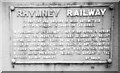
Rhymney Railway sign, Senghenydd
This weight-limit sign, attached to a bridge over the railway line at Senghenydd, was photographed during a photo-stop on a railtour (Image). Notice how all the letters have been picked out in white paint - except the 2 instances of 'Rhymney'! The Rhymney Railway was amalgamated with the GWR during 1922 & so hadn't existed for 46 years.
Image: © Martin Tester
Taken: 13 Apr 1968
0.04 miles
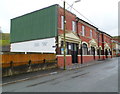
9
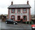
Former County Police Station, Senghenydd
Located on the corner of Gwern Avenue and Kingsley Place. Now a private residence, the former police station dates from 1904.
Image: © Jaggery
Taken: 27 Apr 2012
0.04 miles
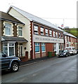
10
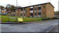
Plas Cwm Parc flats, Senghenydd
This is the southern (Gwern Avenue) side of Plas Cwm Parc which contains about 60 flats.
Image: © Jaggery
Taken: 27 Apr 2012
0.04 miles