1
Head of the Valley, Senghenydd
The former miners' row down in the valley below is lined on both sides by newer housing. Hill farms occupy the hill tops.
Image: © Colin Smith
Taken: 24 Sep 2006
0.03 miles
2
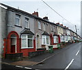
Alexandra Terrace, Senghenydd
Image: © John Lord
Taken: 5 Oct 2017
0.06 miles
3
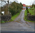
Entrance road to Woodland Farm, Senghenydd
The farm specialises in breeding pigs.
Image: © Jaggery
Taken: 27 Apr 2012
0.07 miles
4
Glan Nant SE of Woodland Terrace, Senghenydd
A stream, Glan Nant, flows under a track near an unnamed road SE of Woodland Terrace.
Image: © Jaggery
Taken: 27 Apr 2012
0.07 miles
5
Two blue weight limit signs at a Senghenydd road junction
Both signs show a 7.5 tonnes vehicle weight limit.
The sign on the left shows that the weight limit applies 330 yards ahead.
The sign on the right shows that the weight limit applies 460 yards ahead.
Image: © Jaggery
Taken: 15 Mar 2019
0.08 miles
6
Path descending towards Senghenydd turning circle
The turning circle is the terminus of Stagecoach bus route B from Caerphilly.
A children's playground https://www.geograph.org.uk/photo/2920296 is on the right.
Image: © Jaggery
Taken: 15 Mar 2019
0.09 miles
7
Path up to Coronation Terrace, Senghenydd
Viewed from an unnamed road south of Woodland Terrace.
Image: © Jaggery
Taken: 27 Apr 2012
0.11 miles
8
Path towards a children's playground, Senghenydd
The playground https://www.geograph.org.uk/photo/2920296 is ahead on the left.
Image: © Jaggery
Taken: 15 Mar 2019
0.11 miles
9
High Street houses on top of a hill, Senghenydd
Looking east from the entrance to the Mining Memorial & Garden site.
Image: © Jaggery
Taken: 26 Mar 2019
0.11 miles
10
Woodland Terrace Senghenydd
This is the SW end of Woodland Terrace, a 120 metre long row of 22 houses.
All the houses in Woodland Terrace are on this side of the street.
Image: © Jaggery
Taken: 27 Apr 2012
0.11 miles


