IMAGES TAKEN NEAR TO
Gwern Avenue, CAERPHILLY, CF83 4HA
Introduction
This page details the photographs taken nearby to Gwern Avenue, CF83 4HA by members of the Geograph project.
The Geograph project started in 2005 with the aim of publishing, organising and preserving representative images for every square kilometre of Great Britain, Ireland and the Isle of Man.

There are currently over 7.5m images from over14,400 individuals and you can help contribute to the project by visiting https://www.geograph.org.uk
Image Map
Images are licensed for reuse under creativecommons.org/licenses/by-sa/2.0
Notes
- Clicking on the map will re-center to the selected point.
- The higher the marker number, the further away the image location is from the centre of the postcode.
Image Listing (134 Images Found)
Images are licensed for reuse under creativecommons.org/licenses/by-sa/2.0
Image
Details
Distance
1
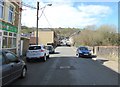
West along Gwern Avenue, Senghenydd
Ming's Chinese takeaway https://www.geograph.org.uk/photo/6100389 is on the left.
Image: © Jaggery
Taken: 26 Mar 2019
0.01 miles
2
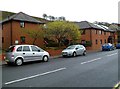
Parrish Place, Senghenydd
Parrish Place contains 18 flats, located on the NE side of Commercial Street.
This view shows numbers 11-18 Parrish Place.
Image: © Jaggery
Taken: 27 Apr 2012
0.03 miles
3
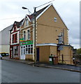
Ming's Chinese Takeaway, Senghenydd
Located at 2 Gwern Avenue.
Image: © Jaggery
Taken: 27 Apr 2012
0.03 miles
4
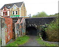
Double arch bridge, Gwern Avenue, Senghenydd
The bridge carries Gwern Avenue above a footpath on the left and a stream, Nant Cwm-parc, on the right. Ming's Chinese Takeaway http://www.geograph.org.uk/photo/2922653 is in the background.
Image: © Jaggery
Taken: 27 Apr 2012
0.03 miles
5
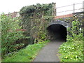
Gwern Avenue underpass, Senghenydd
A path approaches a short tunnel under Gwern Avenue. On the left is a stream, Nant Cwm-parc. It has flowed under the road through a separate short tunnel, the portal of which is covered with ivy and other vegetation.
Image: © Jaggery
Taken: 27 Apr 2012
0.03 miles
6
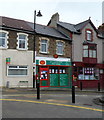
Senghenydd Post Office
Located in High Street, at the junction with Commercial Street.
Image: © Jaggery
Taken: 27 Apr 2012
0.03 miles
7
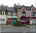
Grade II listed Senghenydd War Memorial
The Memorial is a clock tower located in the centre of Senghenydd, at the junction of High Street, Commercial Street and Gwern Avenue. It was dedicated on March 1st, 1921 in memory of the 62 men from the village who were killed in the Great War (later usually known as the First World War).
The names of those killed in the Second World War were added shortly after the end of that war.
Grade II listed in June 1999.
Image: © Jaggery
Taken: 27 Apr 2012
0.03 miles
8
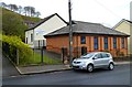
The Salvation Army, Senghenydd
The Salvation Army's Senghenydd Corps is based here, at the southern end of High Street.
Image: © Jaggery
Taken: 27 Apr 2012
0.03 miles
9
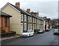
High Street houses south of the Salvation Army site, Senghenydd
High Street in Senghenydd is mostly residential. This is a view south
from alongside the Salvation Army building http://www.geograph.org.uk/photo/2924077 looking towards the central square.
Image: © Jaggery
Taken: 27 Apr 2012
0.03 miles
10
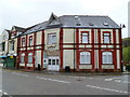
Gwern-Y-Milwr flats, Senghenydd
The building in the centre of Senghenydd, opposite the War Memorial http://www.geograph.org.uk/photo/2922796 was formerly
the Gwern-Y-Milwr Hotel. The building is now divided into flats.
Image: © Jaggery
Taken: 27 Apr 2012
0.03 miles