IMAGES TAKEN NEAR TO
Tan Y Bryn, CAERPHILLY, CF83 4FN
Introduction
This page details the photographs taken nearby to Tan Y Bryn, CF83 4FN by members of the Geograph project.
The Geograph project started in 2005 with the aim of publishing, organising and preserving representative images for every square kilometre of Great Britain, Ireland and the Isle of Man.

There are currently over 7.5m images from over14,400 individuals and you can help contribute to the project by visiting https://www.geograph.org.uk
Image Map
Images are licensed for reuse under creativecommons.org/licenses/by-sa/2.0
Notes
- Clicking on the map will re-center to the selected point.
- The higher the marker number, the further away the image location is from the centre of the postcode.
Image Listing (88 Images Found)
Images are licensed for reuse under creativecommons.org/licenses/by-sa/2.0
Image
Details
Distance
1
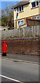
Queen Elizabeth II pillarbox, Caerphilly Road, Senghenydd
Viewed in March 2019. The BT phonebox near the pillarbox
in an October 2015 Google Street View has been removed.
Image: © Jaggery
Taken: 26 Mar 2019
0.06 miles
2
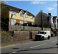
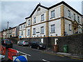
Semis above Caerphilly Road, Senghenydd
Two semi-detached houses set above the east side of the B4263 Caerphilly Road.
Image: © Jaggery
Taken: 26 Mar 2019
0.06 miles
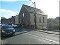
4
Seion 1901 inscription, Senghenydd
The Welsh inscription is on this https://www.geograph.org.uk/photo/2927449 former chapel.
Image: © Jaggery
Taken: 26 Mar 2019
0.06 miles
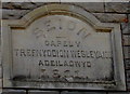
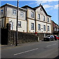
5
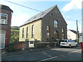
The former Seion Welsh Wesleyan chapel
Now commercial premises?
The inscription on the plaque is 'SEION CAPEL TREFNYDDION WESLEYAID ADEILADWYD 1903'.
Image: © John Lord
Taken: 5 Oct 2017
0.07 miles
6
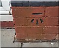
Ordnance Survey Cut Mark
This OS cut mark can be found on No164 Caerphilly Road. It marks a point 171.618m above mean sea level.
Image: © Adrian Dust
Taken: 25 May 2019
0.07 miles
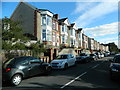
7
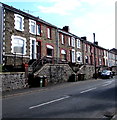
Stone houses above Caerphilly Road, Senghenydd
Above the east side of the B4263 Caerphilly Road in the south of Senghenydd on the approach to Abertridwr.
Image: © Jaggery
Taken: 26 Mar 2019
0.07 miles
8
The former Seion Welsh Wesleyan chapel
Now commercial premises?
Image: © John Lord
Taken: 5 Oct 2017
0.07 miles
9
Meadowhill Court, Senghenydd
Now divided into flats named Meadowhall Court, the building was originally Ebenezer English Baptist chapel built in 1904. https://www.geograph.org.uk/photo/6101219 A row of 10 foundation stones can be seen above the boundary wall alongside the two parked cars.
Image: © Jaggery
Taken: 27 Apr 2012
0.08 miles
10
Meadowhill Court flats, Senghenydd
Meadowhill Court alongside the B4263 was originally Ebenezer English Baptist chapel built in 1904. https://www.geograph.org.uk/photo/6101219
Image: © Jaggery
Taken: 26 Mar 2019
0.08 miles