IMAGES TAKEN NEAR TO
High Street, CAERPHILLY, CF83 4FD
Introduction
This page details the photographs taken nearby to High Street, CF83 4FD by members of the Geograph project.
The Geograph project started in 2005 with the aim of publishing, organising and preserving representative images for every square kilometre of Great Britain, Ireland and the Isle of Man.

There are currently over 7.5m images from over14,400 individuals and you can help contribute to the project by visiting https://www.geograph.org.uk
Image Map
Images are licensed for reuse under creativecommons.org/licenses/by-sa/2.0
Notes
- Clicking on the map will re-center to the selected point.
- The higher the marker number, the further away the image location is from the centre of the postcode.
Image Listing (150 Images Found)
Images are licensed for reuse under creativecommons.org/licenses/by-sa/2.0
Image
Details
Distance
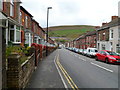
1
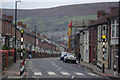
High Street, Abertridwr
Looking along High Street from its junction with Bryn Gelli Terrace towards the centre of this former mining village in the Aber Valley north-west of Caerphilly. Coal mining ceased here more than 30 years ago when the Windsor Colliery, once the major local employer, closed.
Image: © Stephen McKay
Taken: 11 Dec 2008
0.03 miles
2
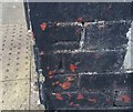
Ordnance Survey Cut Mark
This OS cut mark can be found on No103A High Street. It marks a point 162.532m above mean sea level.
Image: © Adrian Dust
Taken: 25 May 2019
0.04 miles
3
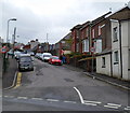
Bryngelli Terrace, Abertridwr
Bryngelli Terrace climbs away from High Street. There is a 20mph maximum speed ahead on the approach to Cwmaber Infant School. http://www.geograph.org.uk/photo/2928228
Image: © Jaggery
Taken: 27 Apr 2012
0.04 miles
4
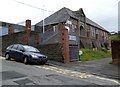
Cwmaber Infant School, Abertridwr
Viewed across Bryngelli Terrace. http://www.geograph.org.uk/photo/2928225
Image: © Jaggery
Taken: 27 Apr 2012
0.04 miles
5
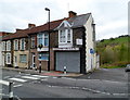
Spice Asia, Abertridwr
Indian cuisine takeaway at 103A High Street.
Image: © Jaggery
Taken: 27 Apr 2012
0.04 miles
7
High Street houses, Abertridwr
Looking south from near the zebra crossing alongside Spice Asia. http://www.geograph.org.uk/photo/2928237
Image: © Jaggery
Taken: 27 Apr 2012
0.08 miles
8
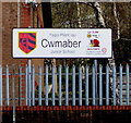
Cwmaber Junior School name sign, Abertridwr
The sign on the right here https://www.geograph.org.uk/photo/2934445 shows that Cwmaber Junior School is Ysgol Plant Iau Cwmaber in Welsh.
Image: © Jaggery
Taken: 28 Mar 2019
0.09 miles
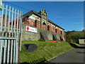
10
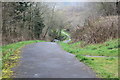
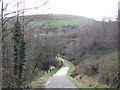
Path to Nant Cwm-parc, Abertridwr
Path from the Aber Cycleway down to the stream (left); the path later climbs to rejoin the Cycleway.
Image: © M J Roscoe
Taken: 11 Apr 2018
0.09 miles