1
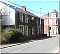
Row of three houses, High Street, Abertridwr
Alongside the B4263 High Street. The Windsor Hotel https://www.geograph.org.uk/photo/2927660 is in the background.
Image: © Jaggery
Taken: 26 Mar 2019
0.00 miles
2
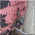
Ordnance Survey Cut Mark
This OS cut mark can be found on No191 High Street. It marks a point 167.799m above mean sea level.
Image: © Adrian Dust
Taken: 25 May 2019
0.01 miles
3
The Windsor Hotel, Senghenydd
Many pubs and clubs have closed in the Aber Valley but this one is still open. It remains to be seen how the smoking ban will affect trade. The road to the right leads to the top of the valley and ultimately over the mountain to the village of Nelson.
Image: © Duncan and Gareth Alderson
Taken: 27 Aug 2007
0.01 miles
4
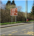
Brown direction sign alongside High Street, Abertridwr
Ahead for the Mining Memorial & Garden and the Aber Valley Heritage Museum. The text is also in Welsh.
Image: © Jaggery
Taken: 26 Mar 2019
0.02 miles
5
The Windsor Hotel, Senghenydd
Image: © John Lord
Taken: 5 Oct 2017
0.02 miles
6
Side road from High Street in Abertridwr
Ascending from High Street towards Gelli Terrace and Edward Terrace.
Image: © Jaggery
Taken: 26 Mar 2019
0.02 miles
7
The Windsor Hotel, Senghenydd
Image: © John Lord
Taken: 5 Oct 2017
0.03 miles
8
High Street bus stop and shelter, Abertridwr
This stop on the east side of the B4263 is for buses to Caerphilly.
Image: © Jaggery
Taken: 26 Mar 2019
0.03 miles
9
Northern boundary of Abertridwr
Caerphilly Road (B4263) leaves Senghenydd and enters the village of Abertridwr (Welsh for mouth of the three waters). Both villages are in the Aber Valley, to the NW of Caerphilly.
Image: © Jaggery
Taken: 27 Apr 2012
0.03 miles
10
Former Chapel, Senghenydd
The village straggles along the valley road and has several chapels. Like this one, many are now closed - or turned into other use eg flats.
Image: © Colin Smith
Taken: 24 Sep 2006
0.03 miles


