1
Abertridwr Library
Part of Caerphilly County Borough's library service, the village library is on the east side of Aberfawr Road at the edge of Abertridwr Park. https://www.geograph.org.uk/photo/6103013 to the library opening hours on display in late March 2019.
Image: © Jaggery
Taken: 28 Mar 2019
0.02 miles
2
Abertridwr Library opening hours
On display on the wall here https://www.geograph.org.uk/photo/6103010 on March 28th 2019.
Abertridwr Library is Llyfrgell Abertridwr in Welsh.
Image: © Jaggery
Taken: 28 Mar 2019
0.02 miles
3
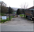
Western entrance to Abertridwr Park, Abertridwr
From Aberfawr Road. Abertridwr Library https://www.geograph.org.uk/photo/6103010 is on the right.
Image: © Jaggery
Taken: 28 Mar 2019
0.02 miles
4
Welcome to Abertridwr Park, Home of Aber Valley F.C.
The Welsh/English sign is on the left here. https://www.geograph.org.uk/photo/6103029
Aber Valley Football Club was established in 2000.
In season 2018/2019 the club plays in the South Wales Alliance League Division 1.
Image: © Jaggery
Taken: 28 Mar 2019
0.02 miles
5
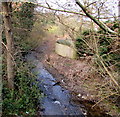
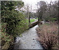
Upstream along Nant yr Aber, Abertridwr
A tributary of the Rhymney River, the stream flows towards the camera on this Aberfawr Road bridge. https://www.geograph.org.uk/photo/6118292
Image: © Jaggery
Taken: 28 Mar 2019
0.02 miles
6
Aberfawr Road semis, Abertridwr
Four semi-detached houses on the west side of Aberfawr Road.
Image: © Jaggery
Taken: 28 Mar 2019
0.02 miles
7
Aberfawr Road bridge, Abertridwr
Aberfawr Road crosses above the stream Nant yr Aber, a tributary of the Rhymney River.
Image: © Jaggery
Taken: 28 Mar 2019
0.03 miles
8
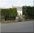
Hedge-lined perimeter of an Aberfawr Road house, Abertridwr
The blue plaque https://www.geograph.org.uk/photo/6102997 shows Old Aberfawr Farmhouse.
Image: © Jaggery
Taken: 28 Mar 2019
0.03 miles
9
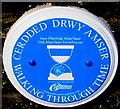
Old Aberfawr Farmhouse blue plaque, Aberfawr Road, Abertridwr
The Caerphilly County Borough Council Walking Through Time blue plaque on the wall here https://www.geograph.org.uk/photo/6102995 shows
Old Aberfawr Farmhouse and its Welsh equivalent.
Image: © Jaggery
Taken: 28 Mar 2019
0.03 miles
10
Nant yr Aber, Abertridwr
Viewed from this https://www.geograph.org.uk/photo/6118292 road bridge, Nant yr Aber flows towards the Rhymney River several kilometres ahead.
Image: © Jaggery
Taken: 28 Mar 2019
0.04 miles


