IMAGES TAKEN NEAR TO
Woodland Terrace, CAERPHILLY, CF83 4DQ
Introduction
This page details the photographs taken nearby to Woodland Terrace, CF83 4DQ by members of the Geograph project.
The Geograph project started in 2005 with the aim of publishing, organising and preserving representative images for every square kilometre of Great Britain, Ireland and the Isle of Man.

There are currently over 7.5m images from over14,400 individuals and you can help contribute to the project by visiting https://www.geograph.org.uk
Image Map
Images are licensed for reuse under creativecommons.org/licenses/by-sa/2.0
Notes
- Clicking on the map will re-center to the selected point.
- The higher the marker number, the further away the image location is from the centre of the postcode.
Image Listing (116 Images Found)
Images are licensed for reuse under creativecommons.org/licenses/by-sa/2.0
Image
Details
Distance
1
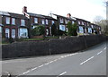
Woodland Terrace, Abertridwr
Houses above the south side of the road. The brook/stream Nant Ilan flows below the north side of the road.
Image: © Jaggery
Taken: 28 Mar 2019
0.00 miles
2
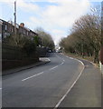
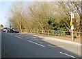
Bend in the road, Abertridwr
From Church Road to Woodland Terrace past the Havard Road junction.
Image: © Jaggery
Taken: 28 Mar 2019
0.01 miles
3
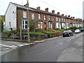
Church Road houses, Abertridwr
A long row of houses on the north side of Church Road, view from opposite the Tridwr Road http://www.geograph.org.uk/photo/2928588 junction.
Image: © Jaggery
Taken: 27 Apr 2012
0.01 miles
4
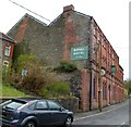
Royal Hotel Abertridwr viewed from the east
Large pub viewed along Church Road. The main entrance is around the corner in Havard Road (wrongly shown in some sources as Harvard Road).
Image: © Jaggery
Taken: 27 Apr 2012
0.01 miles
5
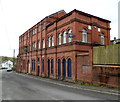
Royal Hotel Abertridwr viewed from the west
Large pub viewed across Church Road. The main entrance is around the corner in Havard Road (wrongly shown in some sources as Harvard Road).
Image: © Jaggery
Taken: 27 Apr 2012
0.01 miles
6
Woodland Terrace bus stop, Abertridwr
In April 2019 this is a stop on Stagecoach Route E to Senghenydd.
The railings and trees are above the stream Nant Ilan.
Image: © Jaggery
Taken: 1 Apr 2019
0.01 miles
7
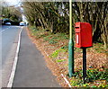
Queen Elizabeth II postbox at the western end of Church Road, Abertridwr
On the right here. https://www.geograph.org.uk/photo/6103499 Woodland Terrace is ahead.
Image: © Jaggery
Taken: 28 Mar 2019
0.01 miles
8
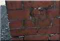
Ordnance Survey Cut Mark
This OS cut mark can be found on the wall of the Royal Hotel. It marks a point 159.718m above mean sea level.
Image: © Adrian Dust
Taken: 25 May 2019
0.02 miles
9
West side of the Royal Hotel, Abertridwr
Viewed across Havard Road. The sign above the doorway shows
ALSO THE HOME OF ABERTRIDWR RUGBY CLUB.
Image: © Jaggery
Taken: 1 Apr 2019
0.03 miles
10

Ordnance Survey Rivet
This OS rivet can be found on the retaining wall above the river. It marks a point 165.238m above mean sea level.
Image: © Adrian Dust
Taken: 25 May 2019
0.04 miles