IMAGES TAKEN NEAR TO
Under The Meio, CAERPHILLY, CF83 4BZ
Introduction
This page details the photographs taken nearby to Under The Meio, CF83 4BZ by members of the Geograph project.
The Geograph project started in 2005 with the aim of publishing, organising and preserving representative images for every square kilometre of Great Britain, Ireland and the Isle of Man.

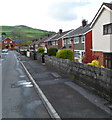
There are currently over 7.5m images from over14,400 individuals and you can help contribute to the project by visiting https://www.geograph.org.uk
Image Map
Images are licensed for reuse under creativecommons.org/licenses/by-sa/2.0
Notes
- Clicking on the map will re-center to the selected point.
- The higher the marker number, the further away the image location is from the centre of the postcode.
Image Listing (181 Images Found)
Images are licensed for reuse under creativecommons.org/licenses/by-sa/2.0
Image
Details
Distance
1
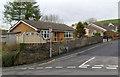
Clos Morgan Gruffydd bungalows, Abertridwr
Viewed from the corner of Church Road. There are no houses on the opposite side of the road, which is occupied by a path http://www.geograph.org.uk/photo/2928576 set a little higher than the level of the roadway.
Image: © Jaggery
Taken: 27 Apr 2012
0.07 miles
2
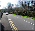
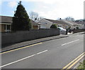
Tridwr Road, Abertriwdr
Tridwr Road climbs away from Church Road.
Image: © Jaggery
Taken: 27 Apr 2012
0.07 miles
3
West side of Clos Morgan Gruffydd, Abertridwr
In March 2019 all the houses https://www.geograph.org.uk/photo/6103194 are on the east side of Clos Morgan Gruffydd.
Image: © Jaggery
Taken: 28 Mar 2019
0.11 miles
4
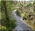
Nant Cwm-parc flows towards Aberfawr Road, Abertridwr
Viewed from this http://www.geograph.org.uk/photo/2934377 bridge. Nant is Welsh for stream.
Image: © Jaggery
Taken: 1 May 2012
0.11 miles
5
NE side of Aberfawr Terrace, Abertridwr
Semi-detached houses on this side of Aberfawr Terrace contrast with a long row of houses on the opposite side. http://www.geograph.org.uk/photo/2934699
Image: © Jaggery
Taken: 1 May 2012
0.11 miles
6
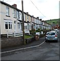
SW side of Aberfawr Terrace, Abertridwr
The long row of houses on this side of Aberfawr Terrace contrasts with the semi-detached houses http://www.geograph.org.uk/photo/2934694 on the opposite side.
Image: © Jaggery
Taken: 1 May 2012
0.11 miles
7
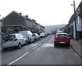
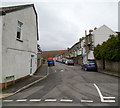
Tridwr Road, Abertridwr
From Church Road along Tridwr Road past speed bumps. Tridwr Road leads to Ilan Road.
Image: © Jaggery
Taken: 28 Mar 2019
0.12 miles
8
Clos Morgan Gruffydd bungalows, Abertridwr
In March 2019 all the houses in Clos Morgan Gruffydd are on one side of the street.
Clos Morgan Gruffydd https://www.geograph.org.uk/photo/6103185 does not have an equivalent English name.
Image: © Jaggery
Taken: 28 Mar 2019
0.12 miles
9
Looking towards the site of the former Abertridwr railway station
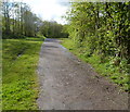
Viewed from near a road bridge http://www.geograph.org.uk/photo/2934565 over the former railway line which entered Abertridwr railway station ahead. The station closed in 1964. There are now only a few remnants hereabouts of the dismantled railway.
Image: © Jaggery
Taken: 1 May 2012
0.12 miles
10
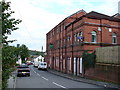
Large Pub in Abertridwr
The large Royal Hotel building is on the road into the village from the west and is a pub of long standing. The pub downhill at the main road junction in the village centre has been closed down. [Cheers to Gethin!]
Image: © Colin Smith
Taken: 24 Sep 2006
0.13 miles