IMAGES TAKEN NEAR TO
Graig-yr-Hufen Road, CAERPHILLY, CF83 4BW
Introduction
This page details the photographs taken nearby to Graig-yr-Hufen Road, CF83 4BW by members of the Geograph project.
The Geograph project started in 2005 with the aim of publishing, organising and preserving representative images for every square kilometre of Great Britain, Ireland and the Isle of Man.

There are currently over 7.5m images from over14,400 individuals and you can help contribute to the project by visiting https://www.geograph.org.uk
Image Map
Images are licensed for reuse under creativecommons.org/licenses/by-sa/2.0
Notes
- Clicking on the map will re-center to the selected point.
- The higher the marker number, the further away the image location is from the centre of the postcode.
Image Listing (28 Images Found)
Images are licensed for reuse under creativecommons.org/licenses/by-sa/2.0
Image
Details
Distance
1
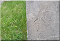
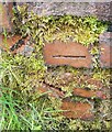
Ordnance Survey Cut Mark
This OS cut mark can be found on the barn at Craig-y-Hufen Farm. It marks a point 295.235m above mean sea level.
Image: © Adrian Dust
Taken: 25 May 2019
0.02 miles
2
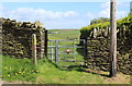
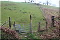
Footpath gate opposite Graig-yr-Hufen Farm
The public footpath runs alongside the fence and then turns downhill to rejoin the road Image cutting out a bend in the road.
Image: © M J Roscoe
Taken: 10 May 2018
0.02 miles
3
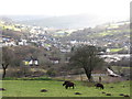
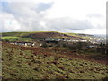
View down the Aber Valley
Looking down on to Senghenydd.
Image: © Gareth James
Taken: 19 Jan 2014
0.10 miles
4
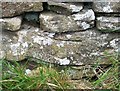
Ordnance Survey Cut Mark
This OS cut mark can be found on the wall east side of the road. It marks a point 306.644m above mean sea level.
Image: © Adrian Dust
Taken: 25 May 2019
0.10 miles
6
Hillside footpath from minor road
Field footpath up to Bwlch Carnygelli cutting a bend in the road to Nelson.
Image: © M J Roscoe
Taken: 11 Apr 2018
0.12 miles
7
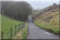
Steep road down to Senghenydd
Minor road to Senghenydd just visible through the mist.
Image: © M J Roscoe
Taken: 11 Apr 2018
0.14 miles
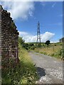
8
Remains of a former bridge from the Universal Colliery
Image: © Gareth James
Taken: 19 Jan 2014
0.15 miles
9
Ordnance Survey Cut Mark
This damaged OS cut mark can be found on the Quarry ruin. It marks a point 276.554m above mean sea level.
Image: © Adrian Dust
Taken: 25 May 2019
0.15 miles
10
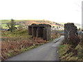
Track above Senghenydd
The ruin to the left is the remains of an old railway bridge.
Image: © Alan Hughes
Taken: 1 Aug 2021
0.16 miles