IMAGES TAKEN NEAR TO
Glenview Terrace, CAERPHILLY, CF83 3TE
Introduction
This page details the photographs taken nearby to Glenview Terrace, CF83 3TE by members of the Geograph project.
The Geograph project started in 2005 with the aim of publishing, organising and preserving representative images for every square kilometre of Great Britain, Ireland and the Isle of Man.

There are currently over 7.5m images from over14,400 individuals and you can help contribute to the project by visiting https://www.geograph.org.uk
Image Map
Images are licensed for reuse under creativecommons.org/licenses/by-sa/2.0
Notes
- Clicking on the map will re-center to the selected point.
- The higher the marker number, the further away the image location is from the centre of the postcode.
Image Listing (56 Images Found)
Images are licensed for reuse under creativecommons.org/licenses/by-sa/2.0
Image
Details
Distance
1
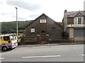
Seion Baptist Church, Llanbradach
For Sale.
Image: © John Lord
Taken: 26 Aug 2017
0.00 miles
2
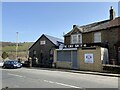
Chapel and Chips
Seion Chapel, Llanbradach.
Image: © Alan Hughes
Taken: 30 Mar 2021
0.01 miles
3
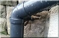
Ordnance Survey Cut Mark
This OS cut mark can be found on the Sion Baptist Chapel, Glenview Terrace. It marks a point 87.075m above mean sea level.
Image: © Adrian Dust
Taken: 5 Feb 2021
0.01 miles
4
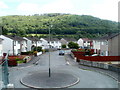
Garden Close, Llanbradach
Viewed from Glenview Terrace. Garden Close is accessed via Garden Street.
Image: © Jaggery
Taken: 22 Jun 2011
0.01 miles
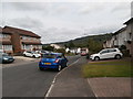
6
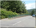
Elevated pavement on the west side of Glenview Terrace, Llanbradach
The pavement is raised above road level for about 100 metres.
Image: © Jaggery
Taken: 22 Jun 2011
0.05 miles
7
Large Llanbradach name sign alongside Glenview Terrace
The name sign faces Rue de Ploubezre, http://www.geograph.org.uk/photo/2920150 the link road from the A469.
Image: © Jaggery
Taken: 22 Jun 2011
0.07 miles
8
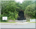
Nant Owen, Llanbradach
A stream, Nant Owen, descends a small stepped waterfall on the west side of Glenview Terrace. Nant Owen is a tributary of the Rhymney River into which it flows about 200 metres behind the camera.
The sign on the left shows that Llanbradach (and the adjoining community of Pwll-y-pant) is twinned with Ploubezre, a commune in Brittany, NW France.
Image: © Jaggery
Taken: 22 Jun 2011
0.07 miles
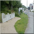
9
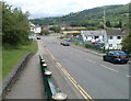
Northern end of Glenview Terrace, Llanbradach
Viewed from the elevated pavement http://www.geograph.org.uk/photo/2920096 on the west side of the road. Ahead on the right are the premises of Star Hand Car Wash. The premises were formerly occupied by Walrus Valeting.
Image: © Jaggery
Taken: 22 Jun 2011
0.07 miles
10
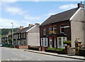
Glenview Terrace, Llanbradach
The house on the right is at the SW end of Glenview Terrace, adjacent to the NE end of Ffrwd Terrace out of shot on the right.
Image: © Jaggery
Taken: 22 Jun 2011
0.08 miles