IMAGES TAKEN NEAR TO
Colliery Road, CAERPHILLY, CF83 3TA
Introduction
This page details the photographs taken nearby to Colliery Road, CF83 3TA by members of the Geograph project.
The Geograph project started in 2005 with the aim of publishing, organising and preserving representative images for every square kilometre of Great Britain, Ireland and the Isle of Man.

There are currently over 7.5m images from over14,400 individuals and you can help contribute to the project by visiting https://www.geograph.org.uk
Image Map
Images are licensed for reuse under creativecommons.org/licenses/by-sa/2.0
Notes
- Clicking on the map will re-center to the selected point.
- The higher the marker number, the further away the image location is from the centre of the postcode.
Image Listing (31 Images Found)
Images are licensed for reuse under creativecommons.org/licenses/by-sa/2.0
Image
Details
Distance
1
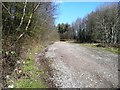
Access to woods above Llanbradach
A typical forest track at its lower end.
Image: © Graham Horn
Taken: 21 Mar 2008
0.05 miles
2
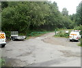
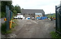
Car park and barrier at the edge of woodland, Llanbradach
At the edge of the former Llanbradach Colliery site (now used by a variety of businesses), a green barrier prevents vehicles entering a path through woodland. Viewed from Colliery Road.
Image: © Jaggery
Taken: 22 Jun 2011
0.07 miles
3

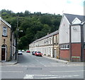
Houses at the southern end of Wingfield Crescent, Llanbradach
The long row of houses is on the west side of the road.
Image: © Jaggery
Taken: 22 Jun 2011
0.08 miles
5
Oakfield Street, Llanbradach
Looking west from Wingfield Crescent. The street ends at the edge of a wood, Coed Llangwm.
The corner building on the right is Llanbradach Old Comrades Club & Institute. http://www.geograph.org.uk/photo/2921925
Image: © Jaggery
Taken: 22 Jun 2011
0.11 miles
6
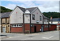
Former colliery winding house, Llanbradach
The winding house, part of Llanbradach Colliery which closed in 1961, is now the premises
of DnA Heating Ltd who undertake plumbing, heating and related maintenance work.
Image: © Jaggery
Taken: 22 Jun 2011
0.12 miles
7
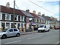
Wingfield Stores, Llanbradach
One shop in a long row of houses, Wingfield Stores is located at 41 Wingfield Crescent. A sign on the wall shows grocer, confectioner, tobacconist, off licence.
Image: © Jaggery
Taken: 22 Jun 2011
0.13 miles
8
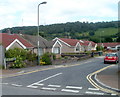
Lon-yr-afon bungalows, Llanbradach
Bungalows on the north side of the street, viewed from the corner of Wingfield Crescent.
Image: © Jaggery
Taken: 22 Jun 2011
0.14 miles

10
Llanbradach Old Comrades Club & Institute
Ex-servicemen's club on the corner of Wingfield Crescent and Oakfield Street.
Image: © Jaggery
Taken: 22 Jun 2011
0.16 miles