IMAGES TAKEN NEAR TO
Clos De Winton, CAERPHILLY, CF83 3SF
Introduction
This page details the photographs taken nearby to Clos De Winton, CF83 3SF by members of the Geograph project.
The Geograph project started in 2005 with the aim of publishing, organising and preserving representative images for every square kilometre of Great Britain, Ireland and the Isle of Man.

There are currently over 7.5m images from over14,400 individuals and you can help contribute to the project by visiting https://www.geograph.org.uk
Image Map
Images are licensed for reuse under creativecommons.org/licenses/by-sa/2.0
Notes
- Clicking on the map will re-center to the selected point.
- The higher the marker number, the further away the image location is from the centre of the postcode.
Image Listing (155 Images Found)
Images are licensed for reuse under creativecommons.org/licenses/by-sa/2.0
Image
Details
Distance
1
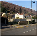
Fenced-off site of the demolished De Winton Hotel, Llanbradach
Viewed in January 2019. This https://www.geograph.org.uk/photo/2473729 2011 photo shows the De Winton Hotel.
Image: © Jaggery
Taken: 4 Jan 2019
0.00 miles
2
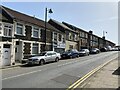
High Street, Llanbradach
View south along High Street.
Image: © Alan Hughes
Taken: 30 Mar 2021
0.01 miles
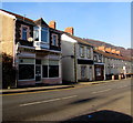
4
J D & M Wheeler, Llanbradach
Family butchers shop at 5 De Winton Terrace.
Image: © Jaggery
Taken: 4 Jan 2019
0.02 miles
5
Telecoms cabinets, De Winton Terrace, Llanbradach
The two green cabinets are alongside a lamppost.
Image: © Jaggery
Taken: 4 Jan 2019
0.02 miles
6
Rockwood Pet Centre, Lewis Terrace, Llanbradach
Dog grooming parlour and dog training business.
Image: © Jaggery
Taken: 4 Jan 2019
0.02 miles
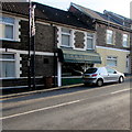
7
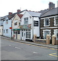
Llanbradach post office
Located at 5 Oak Terrace, next door to a tattoo studio.
Image: © Jaggery
Taken: 22 Jun 2011
0.03 miles
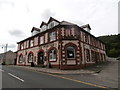
8
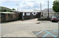
Llanbradach Bowling Club
Llanbradach Bowling Club was founded in 1901. Their clubhouse is set back from the southern end of High Street. The club's bowling green is behind the building.
Image: © Jaggery
Taken: 22 Jun 2011
0.03 miles
9
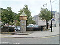
Llanbradach Follies (1)
Located on the corner of High Street and Station Road, this turret is one of two http://www.geograph.org.uk/photo/2473819 5-metre tall towers facing each other across High Street. Sometimes referred to as the Llanbradach Follies, they were commissioned by the Llanbradach and Pwll-y-pant Community Partnership in February 2008. The turrets were designed by J. Kay Aplin. Their purpose was to introduce a spirit of renewal to help Llanbradach flourish in the 21st century, and to create a sense of identity within the village centre.
Image: © Jaggery
Taken: 22 Jun 2011
0.03 miles
10
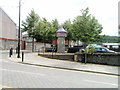
Llanbradach Follies (2)
Located at the top of a small flight of steps at the southern end of High Street.
This is one of two towers created by J.Kay Aplin. The other one http://www.geograph.org.uk/photo/2473816 faces it on the opposite side of the street.
Image: © Jaggery
Taken: 22 Jun 2011
0.03 miles