IMAGES TAKEN NEAR TO
Lewis Drive, CAERPHILLY, CF83 3RE
Introduction
This page details the photographs taken nearby to Lewis Drive, CF83 3RE by members of the Geograph project.
The Geograph project started in 2005 with the aim of publishing, organising and preserving representative images for every square kilometre of Great Britain, Ireland and the Isle of Man.

There are currently over 7.5m images from over14,400 individuals and you can help contribute to the project by visiting https://www.geograph.org.uk
Image Map
Images are licensed for reuse under creativecommons.org/licenses/by-sa/2.0
Notes
- Clicking on the map will re-center to the selected point.
- The higher the marker number, the further away the image location is from the centre of the postcode.
Image Listing (53 Images Found)
Images are licensed for reuse under creativecommons.org/licenses/by-sa/2.0
Image
Details
Distance
1
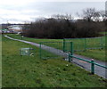
Abandoned Asda trolley about 200 metres from home, Caerphilly
The trolley is near the Lewis Drive end of the path to Asda. http://www.geograph.org.uk/photo/3817092
Image: © Jaggery
Taken: 17 Jan 2014
0.02 miles
2
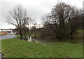
Waterlogged ground near Asda, Caerphilly
A small pond has formed near the path from Lewis Drive to Asda http://www.geograph.org.uk/photo/3817092 in mid-January 2014.
Image: © Jaggery
Taken: 17 Jan 2014
0.05 miles
3
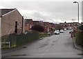
Dyfed Drive, Caerphilly
A 120 metre long cul-de-sac on the south side of Lewis Drive.
Image: © Jaggery
Taken: 17 Jan 2014
0.06 miles
4
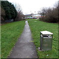
Path from Lewis Drive to Asda, Caerphilly
Puddles are on the path ahead, and waterlogged ground nearby. http://www.geograph.org.uk/photo/3817133 Viewed in mid January 2014.
Image: © Jaggery
Taken: 17 Jan 2014
0.08 miles
5
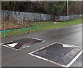
Speed bumps and an abandoned trolley, Lewis Drive, Caerphilly
On the grass behind the bumps is an upturned supermarket trolley, its wheels pointing skywards.
It probably belongs to the nearby Asda. http://www.geograph.org.uk/photo/3817092 A railway perimeter fence is in the background.
Image: © Jaggery
Taken: 17 Jan 2014
0.08 miles
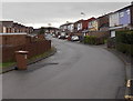
6
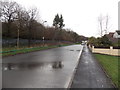
Lewis Drive, Churchill Park, Caerphilly
Looking north from near the Stanley Drive junction.
Image: © Jaggery
Taken: 17 Jan 2014
0.08 miles
7
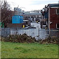
Pipes and tanks in Pontygwindy Industrial Estate, Caerphilly
Viewed from near this http://www.geograph.org.uk/photo/3817190 path.
Image: © Jaggery
Taken: 17 Jan 2014
0.09 miles
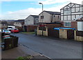
8
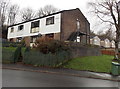
Corner of Lewis Drive and Davies Drive, Caerphilly
There are four flats on the left, in Lewis Drive. Numbers on the white cladding show that the external stairs lead to number 84, above number 83. The houses in the background are in Davies Drive.
Image: © Jaggery
Taken: 17 Jan 2014
0.09 miles
9
Stanley Drive houses, Churchill Park, Caerphilly
Stanley Drive is a short cul-de-sac on the east side of Lewis Drive.
Image: © Jaggery
Taken: 17 Jan 2014
0.09 miles
10
Howard Drive, Caerphilly
A 160 metre long cul-de-sac on the south side of Lewis Drive.
Image: © Jaggery
Taken: 17 Jan 2014
0.10 miles