IMAGES TAKEN NEAR TO
Pencerrig Street, CAERPHILLY, CF83 3LR
Introduction
This page details the photographs taken nearby to Pencerrig Street, CF83 3LR by members of the Geograph project.
The Geograph project started in 2005 with the aim of publishing, organising and preserving representative images for every square kilometre of Great Britain, Ireland and the Isle of Man.

There are currently over 7.5m images from over14,400 individuals and you can help contribute to the project by visiting https://www.geograph.org.uk
Image Map
Images are licensed for reuse under creativecommons.org/licenses/by-sa/2.0
Notes
- Clicking on the map will re-center to the selected point.
- The higher the marker number, the further away the image location is from the centre of the postcode.
Image Listing (155 Images Found)
Images are licensed for reuse under creativecommons.org/licenses/by-sa/2.0
Image
Details
Distance
1

Large derelict building on the corner of Pencerrig Street and Church Street, Llanbradach
The building, appearing long derelict, is about 30 metres long. It is located near the private residence that was formerly All Saints Vicarage. The building is at the western edge of a plot of waste ground about 60 metres by 35 metres, the site of All Saints Church which was demolished in the 1990s.
Is this derelict building the former All Saints church hall?
Image: © Jaggery
Taken: 22 Jun 2011
0.01 miles
2
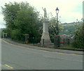
Llanbradach War Memorial
Located on High Street, facing waste ground alongside Pencerrig Street, site of the demolished All Saints church.
Image: © Jaggery
Taken: 22 Jun 2011
0.01 miles
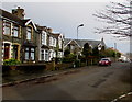
3
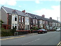
Park View houses, Llanbradach
Located immediately north of High Street and the War Memorial. http://www.geograph.org.uk/photo/2918522
Image: © Jaggery
Taken: 22 Jun 2011
0.01 miles
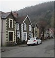
4
Church Street, Llanbradach
Houses on the west side of the street, viewed from Morgan Street.
Image: © Jaggery
Taken: 22 Jun 2011
0.01 miles
5

Derelict chapel (?), junction of Pencerrig St and Church St, Llanbradach
Disappearing behind ever-growing hedge.
Image: © John Lord
Taken: 26 Aug 2017
0.02 miles
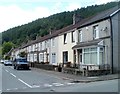
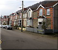
6
Pencerrig Street, Llanbradach
Stone houses on the south side of the street.
Image: © Jaggery
Taken: 14 Feb 2019
0.02 miles
7
Church Street, Llanbradach
From Pencerrig Street along Church Street towards Morgan Street.
Image: © Jaggery
Taken: 14 Feb 2019
0.03 miles
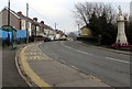
8
West side of Tyn-y-graig Road, Llanbradach
Houses on the west side of the road viewed looking south from the corner of Pencerrig Street.
Image: © Jaggery
Taken: 14 Feb 2019
0.03 miles
9
War Memorial bus stop and shelter, Llanbradach
This stop opposite the War Memorial https://www.geograph.org.uk/photo/6059226 is for buses to Ystrad Mynach, Nelson and Bargoed.
Image: © Jaggery
Taken: 14 Feb 2019
0.04 miles
10
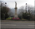
Grade II listed Llanbradach War Memorial
The War Memorial features a marble figure of a classically-robed female bearing
a crucifix, with her right hand raised in blessing. Grade II listed in 1999.
Image: © Jaggery
Taken: 14 Feb 2019
0.04 miles