IMAGES TAKEN NEAR TO
Grove Street, CAERPHILLY, CF83 3LN
Introduction
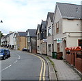
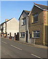
This page details the photographs taken nearby to Grove Street, CF83 3LN by members of the Geograph project.
The Geograph project started in 2005 with the aim of publishing, organising and preserving representative images for every square kilometre of Great Britain, Ireland and the Isle of Man.

There are currently over 7.5m images from over14,400 individuals and you can help contribute to the project by visiting https://www.geograph.org.uk
Image Map
Images are licensed for reuse under creativecommons.org/licenses/by-sa/2.0
Notes
- Clicking on the map will re-center to the selected point.
- The higher the marker number, the further away the image location is from the centre of the postcode.
Image Listing (154 Images Found)
Images are licensed for reuse under creativecommons.org/licenses/by-sa/2.0
Image
Details
Distance
1
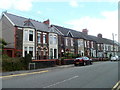
High Street houses, Llanbradach
Houses on the east side of High Street, north of the Post Office and south of the War Memorial.
Image: © Jaggery
Taken: 22 Jun 2011
0.03 miles
2
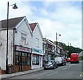
A takeaway and a pharmacy, Llanbradach High Street
The businesses on the west side of High Street are
Golden Way, Chinese and Cantonese takeaway and fish bar,
and The Co-operative Pharmacy.
Image: © Jaggery
Taken: 22 Jun 2011
0.03 miles
3
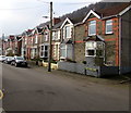
West side of Tyn-y-graig Road, Llanbradach
Houses on the west side of the road viewed looking south from the corner of Pencerrig Street.
Image: © Jaggery
Taken: 14 Feb 2019
0.03 miles
4
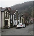
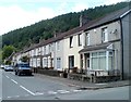
Pencerrig Street, Llanbradach
Stone houses on the south side of the street.
Image: © Jaggery
Taken: 14 Feb 2019
0.03 miles
5

Large derelict building on the corner of Pencerrig Street and Church Street, Llanbradach
The building, appearing long derelict, is about 30 metres long. It is located near the private residence that was formerly All Saints Vicarage. The building is at the western edge of a plot of waste ground about 60 metres by 35 metres, the site of All Saints Church which was demolished in the 1990s.
Is this derelict building the former All Saints church hall?
Image: © Jaggery
Taken: 22 Jun 2011
0.04 miles
6
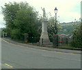
Llanbradach War Memorial
Located on High Street, facing waste ground alongside Pencerrig Street, site of the demolished All Saints church.
Image: © Jaggery
Taken: 22 Jun 2011
0.04 miles
7
Park View houses, Llanbradach
Located immediately north of High Street and the War Memorial. http://www.geograph.org.uk/photo/2918522
Image: © Jaggery
Taken: 22 Jun 2011
0.04 miles
8
Church Street, Llanbradach
Houses on the west side of the street, viewed from Morgan Street.
Image: © Jaggery
Taken: 22 Jun 2011
0.04 miles
9
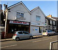
Golden Way in Llanbradach
Golden Way Chinese & Cantonese cuisine takeaway is at 34 High Street viewed in January 2019.
Well Pharmacy next door was a Co-operative Pharmacy in June 2011. https://www.geograph.org.uk/photo/2918191
Image: © Jaggery
Taken: 4 Jan 2019
0.04 miles
10
Group of small railings on the east side of High Street, Llanbradach
On the approach to, and outside, Llanbradach OAP and Welfare Hall. https://www.geograph.org.uk/photo/6029556
Image: © Jaggery
Taken: 4 Jan 2019
0.04 miles