IMAGES TAKEN NEAR TO
Castell Y Fan, CAERPHILLY, CF83 3JL
Introduction
This page details the photographs taken nearby to Castell Y Fan, CF83 3JL by members of the Geograph project.
The Geograph project started in 2005 with the aim of publishing, organising and preserving representative images for every square kilometre of Great Britain, Ireland and the Isle of Man.

There are currently over 7.5m images from over14,400 individuals and you can help contribute to the project by visiting https://www.geograph.org.uk
Image Map
Images are licensed for reuse under creativecommons.org/licenses/by-sa/2.0
Notes
- Clicking on the map will re-center to the selected point.
- The higher the marker number, the further away the image location is from the centre of the postcode.
Image Listing (87 Images Found)
Images are licensed for reuse under creativecommons.org/licenses/by-sa/2.0
Image
Details
Distance
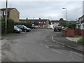
1
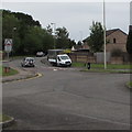
Driving along Heol Ty Merchant, Caerphilly
From the road named Parc Pontypandy, cars in Heol Ty Merchant
approach an area of housing where streets have Welsh-only names.
A sign warns of humps across the road for 650 yards ahead.
Image: © Jaggery
Taken: 19 Jun 2019
0.03 miles
2
Parc Pontypandy houses, Caerphilly
Viewed from the edge of a Pizza Hut. http://www.geograph.org.uk/photo/3161331
Image: © Jaggery
Taken: 13 Aug 2011
0.03 miles
3
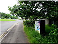
Telecoms cabinet, Parc Pontypandy, Caerphilly
In June 2019 text on the BT/Openreach cabinet includes Fibre broadband is here.
Image: © Jaggery
Taken: 19 Jun 2019
0.04 miles
4
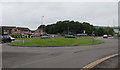
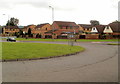
Grassy roundabout, Parc Pontypandy, Caerphilly
The 22 metres diameter roundabout is on the road named Parc Pontypandy at the Heol Ty Merchant junction.
Image: © Jaggery
Taken: 19 Jun 2019
0.04 miles
5
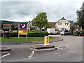
Premier Inn and Brewers Fayre, Crossways, Caerphilly
The interconnected buildings are located between Parc Pandy and the A468. Premier Inn is on the left. Brewers Fayre is a restaurant whose mission statement is 'To serve our guests the nation's favourite pub food, at great value for money, in a family friendly environment.'
Image: © Jaggery
Taken: 13 Aug 2011
0.04 miles
7
Linden Grove, Caerphilly
Cul-de-sac on the north side of Sir Stafford Close.
Image: © Jaggery
Taken: 19 Jun 2019
0.06 miles
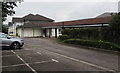
8
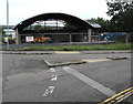
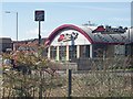
Fenced-off shell of a former Pizza Hut, Caerphilly
Viewed in June 2019. Pizza Hut was here in August 2011. https://www.geograph.org.uk/photo/3161331
Image: © Jaggery
Taken: 19 Jun 2019
0.06 miles
9
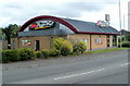
Pizza Hut, Caerphilly
Located on the edge of Gallagher Retail Park near Parc Pontypandy. http://www.geograph.org.uk/photo/3161320
Image: © Jaggery
Taken: 13 Aug 2011
0.06 miles