IMAGES TAKEN NEAR TO
Castell Morgraig, CAERPHILLY, CF83 3JH
Introduction
This page details the photographs taken nearby to Castell Morgraig, CF83 3JH by members of the Geograph project.
The Geograph project started in 2005 with the aim of publishing, organising and preserving representative images for every square kilometre of Great Britain, Ireland and the Isle of Man.

There are currently over 7.5m images from over14,400 individuals and you can help contribute to the project by visiting https://www.geograph.org.uk
Image Map
Images are licensed for reuse under creativecommons.org/licenses/by-sa/2.0
Notes
- Clicking on the map will re-center to the selected point.
- The higher the marker number, the further away the image location is from the centre of the postcode.
Image Listing (96 Images Found)
Images are licensed for reuse under creativecommons.org/licenses/by-sa/2.0
Image
Details
Distance
1
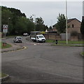
Driving along Heol Ty Merchant, Caerphilly
From the road named Parc Pontypandy, cars in Heol Ty Merchant
approach an area of housing where streets have Welsh-only names.
A sign warns of humps across the road for 650 yards ahead.
Image: © Jaggery
Taken: 19 Jun 2019
0.05 miles
2
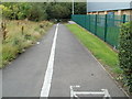
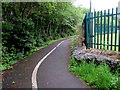
Cycleway and footpath along the edge of Crossways Retail Park, Caerphilly
At the SW side of the retail park, the cycleway and path passes along the edge of FW Home Stores. http://www.geograph.org.uk/photo/3161552
Image: © Jaggery
Taken: 13 Aug 2011
0.05 miles
3
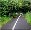
Inwardly-sloping barrier across a path, Caerphilly
Across a combined footpath and cycleway at the edge of Gallagher Retail Park.
The barrier was manufactured by Fearn Truck Bodies Ltd in Rotherham, South Yorkshire.
Image: © Jaggery
Taken: 19 Jun 2019
0.05 miles
4
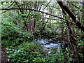
White water on Nant yr Aber, Caerphilly
Nant yr Aber is a tributary of the Rhymney River.
Image: © Jaggery
Taken: 19 Jun 2019
0.05 miles
5
Bend in a brookside path, Caerphilly
Combined footpath and cycleway on a bank of the brook Nant yr Aber, a tributary of the Rhymney River.
Image: © Jaggery
Taken: 19 Jun 2019
0.06 miles
6
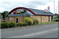
Pizza Hut, Caerphilly
Located on the edge of Gallagher Retail Park near Parc Pontypandy. http://www.geograph.org.uk/photo/3161320
Image: © Jaggery
Taken: 13 Aug 2011
0.07 miles
7
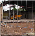
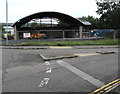
Yellow Thwaites Dumper in a Caerphilly building site
The dumper is inside the fenced-off shell of a former Pizza Hut in June 2019.
Image: © Jaggery
Taken: 19 Jun 2019
0.07 miles
8
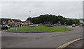
Grassy roundabout, Parc Pontypandy, Caerphilly
The 22 metres diameter roundabout is on the road named Parc Pontypandy at the Heol Ty Merchant junction.
Image: © Jaggery
Taken: 19 Jun 2019
0.07 miles

10
Fenced-off shell of a former Pizza Hut, Caerphilly
Viewed in June 2019. Pizza Hut was here in August 2011. https://www.geograph.org.uk/photo/3161331
Image: © Jaggery
Taken: 19 Jun 2019
0.08 miles