IMAGES TAKEN NEAR TO
CAERPHILLY, CF83 3GL
Introduction
This page details the photographs taken nearby to CF83 3GL by members of the Geograph project.
The Geograph project started in 2005 with the aim of publishing, organising and preserving representative images for every square kilometre of Great Britain, Ireland and the Isle of Man.

There are currently over 7.5m images from over14,400 individuals and you can help contribute to the project by visiting https://www.geograph.org.uk
Image Map
Images are licensed for reuse under creativecommons.org/licenses/by-sa/2.0
Notes
- Clicking on the map will re-center to the selected point.
- The higher the marker number, the further away the image location is from the centre of the postcode.
Image Listing (44 Images Found)
Images are licensed for reuse under creativecommons.org/licenses/by-sa/2.0
Image
Details
Distance
1
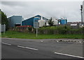
Catnic head office, Pontypandy Industrial Estate, Caerphilly
A manufacturer of steel construction products for the residential sector,
Catnic brought the original steel lintel to the construction industry in 1969.
Image: © Jaggery
Taken: 19 Jun 2019
0.01 miles
2
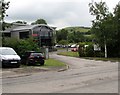
Kingsmead house construction site, Caerphilly
The Taylor Wimpey Kingsmead development of 2- 3- and 4-bedroom
houses viewed from the corner of Pontygwindy Road in June 2019.
Image: © Jaggery
Taken: 19 Jun 2019
0.04 miles
3
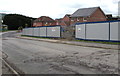
Kingsmead, Caerphilly
The Pontygwindy Road corner of the Taylor Wimpey Kingsmead
development of 2- 3- and 4-bedroom houses viewed in June 2019.
Image: © Jaggery
Taken: 19 Jun 2019
0.04 miles
4
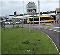
Pwllypant Roundabout directions sign, Caerphilly
Alongside Pontygwindy Road on the southern approach to Pwllypant Roundabout.
Image: © Jaggery
Taken: 19 Jun 2019
0.05 miles
5
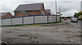
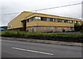
Castle Dairies, Caerphilly
Located in Pontygwindy Industrial Estate, viewed across Pontygwindy Road in the north of Caerphilly.
Image: © Jaggery
Taken: 19 Jun 2019
0.06 miles
6
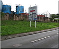
Northern boundary sign, Caerphilly
Alongside Pontygwindy Road near the Pwllypant Roundabout, the sign shows that
Caerphilly (Caerffili in Welsh) is twinned with Lannion (in Brittany, France).
Image: © Jaggery
Taken: 19 Jun 2019
0.06 miles
7
End of Clearway signs, Pontygwindy Road, Caerphilly
The clearway (no parking or stopping except in an emergency)
on the A468 behind the camera ends here. Diwedd is Welsh for end.
Image: © Jaggery
Taken: 19 Jun 2019
0.07 miles
8
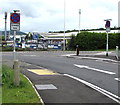
Pwllypant Roundabout
Traffic island A468/A469 junction
Image: © David Dixon
Taken: 30 Aug 2012
0.07 miles
9
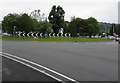
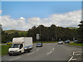
Pwllypant Roundabout near Caerphilly
57 metres diameter roundabout in the middle of the junctions of
the A468, A469 and Pontygwindy Road near the northern edge of Caerphilly.
Image: © Jaggery
Taken: 19 Jun 2019
0.08 miles
10
Derelict former Kobusch premises, Pontygwindy Industrial Estate, Caerphilly
The name of the former packaging firm remains on the derelict building in June 2019.
Image: © Jaggery
Taken: 19 Jun 2019
0.09 miles