IMAGES TAKEN NEAR TO
Glyn Derw, CAERPHILLY, CF83 3EZ
Introduction
This page details the photographs taken nearby to Glyn Derw, CF83 3EZ by members of the Geograph project.
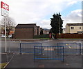
The Geograph project started in 2005 with the aim of publishing, organising and preserving representative images for every square kilometre of Great Britain, Ireland and the Isle of Man.

There are currently over 7.5m images from over14,400 individuals and you can help contribute to the project by visiting https://www.geograph.org.uk
Image Map
Images are licensed for reuse under creativecommons.org/licenses/by-sa/2.0
Notes
- Clicking on the map will re-center to the selected point.
- The higher the marker number, the further away the image location is from the centre of the postcode.
Image Listing (53 Images Found)
Images are licensed for reuse under creativecommons.org/licenses/by-sa/2.0
Image
Details
Distance
1
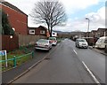
Islwyn Drive, Churchill Park, Caerphilly
Looking east from the Lewis Drive end.
Image: © Jaggery
Taken: 17 Jan 2014
0.05 miles
2
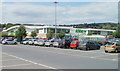
Asda superstore and car park, Caerphilly
Viewed from the SE corner of the site, on the west side of Pontygwindy Road (A469).
Image: © Jaggery
Taken: 19 May 2011
0.09 miles
3
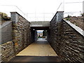
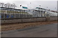
Railway underpass near Energlyn & Churchill Park railway station, Caerphilly
This is the eastern path connecting the station with Lewis Drive ahead. The path passes under the railway a few metres from the newly built station (officially opened in December 2013).
Image: © Jaggery
Taken: 17 Jan 2014
0.10 miles
4
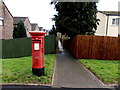
Lewis Drive postbox, Churchill Park, Caerphilly
Facing an entrance to Energlyn & Churchill Park railway station. The postbox used to be on the opposite side of the road. It was moved here to make space for the erection of the safety railings seen here. http://www.geograph.org.uk/photo/3934713
Image: © Jaggery
Taken: 17 Jan 2014
0.10 miles
5
Lewis Drive railway station exit path railings, Churchill Park, Caerphilly
The railings are at the end of the eastern exit from Energlyn & Churchill Park railway station.
The postbox http://www.geograph.org.uk/photo/3934702 used to be on this side of the road. It was moved to make space for these railings during work on the construction of the new railway station, which was officially opened in December 2013.
Image: © Jaggery
Taken: 17 Jan 2014
0.11 miles
6
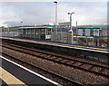
Facilities at Energlyn & Churchill Park railway station, Caerphilly
Platform 1 viewed from platform 2. The unstaffed station, opened in December 2013, has information boards, a shelter and, of course, CCTV cameras. There is a ticket machine outside, and a station car park. The station is on the Rhymney Line between Aber and Llanbradach.
Image: © Jaggery
Taken: 17 Jan 2014
0.12 miles
7
East side of Energlyn & Churchill Park railway station, Caerphilly
Viewed from Lewis Drive. The newly-built station http://www.geograph.org.uk/photo/3822804 was officially opened in December 2013.
Image: © Jaggery
Taken: 17 Jan 2014
0.12 miles
8
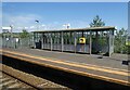
Shelter, on Energlyn and Churchill Park railway station
Image: © Roger Cornfoot
Taken: 9 Aug 2022
0.12 miles
9
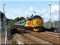
Class 37 at Energlyn & Churchill Park
Class 37 No. 37421 pauses at Energlyn & Churchill Park station while working a Rhymney to Cardiff Canton training run. One locomotive-hauled commuter train service has recently been (re-)introduced to the Rhymney line, with a second set due to enter service soon.
Image: © Gareth James
Taken: 12 Jul 2019
0.13 miles
10
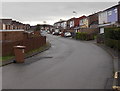
Howard Drive, Caerphilly
A 160 metre long cul-de-sac on the south side of Lewis Drive.
Image: © Jaggery
Taken: 17 Jan 2014
0.13 miles