IMAGES TAKEN NEAR TO
Rudry, CAERPHILLY, CF83 3EG
Introduction
This page details the photographs taken nearby to CF83 3EG by members of the Geograph project.
The Geograph project started in 2005 with the aim of publishing, organising and preserving representative images for every square kilometre of Great Britain, Ireland and the Isle of Man.

There are currently over 7.5m images from over14,400 individuals and you can help contribute to the project by visiting https://www.geograph.org.uk
Image Map
Images are licensed for reuse under creativecommons.org/licenses/by-sa/2.0
Notes
- Clicking on the map will re-center to the selected point.
- The higher the marker number, the further away the image location is from the centre of the postcode.
Image Listing (18 Images Found)
Images are licensed for reuse under creativecommons.org/licenses/by-sa/2.0
Image
Details
Distance
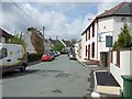
1
Entrance to Rudry's Lair Industrial Units, Rudry
Viewed from the main road through the village.
Image: © Jaggery
Taken: 18 Nov 2011
0.06 miles
2
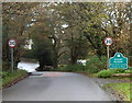
Rudry boundary sign
I was surprised to find the boundary sign here. Although the main residential part of Rudry is ahead, the village school http://www.geograph.org.uk/photo/3062912 and parish hall http://www.geograph.org.uk/photo/3062986 are behind the camera.
Image: © Jaggery
Taken: 18 Nov 2011
0.06 miles
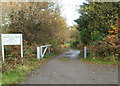
3
Lane to Hollybush Cottage and The Croft, Rudry
Viewed from the main road through Rudry.
Image: © Jaggery
Taken: 18 Nov 2011
0.06 miles
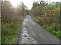
4
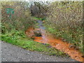
Discoloured stream, Rudry
Viewed from the corner of the main road through the village and a lane. http://www.geograph.org.uk/photo/3063097
Rust-coloured water is usually an indication of iron working (past or present) nearby.
Image: © Jaggery
Taken: 18 Nov 2011
0.06 miles
5
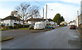
Bryngolau and Garth Place, Rudry
Bryngolau houses are on the left, Garth Place on the right.
Image: © Jaggery
Taken: 18 Nov 2011
0.11 miles
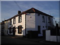
8
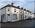
Former post office, Rudry
A postbox set into the wall is a reminder that the corner property was formerly the village post office.
Image: © Jaggery
Taken: 18 Nov 2011
0.15 miles
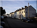
9
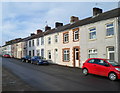
Garth Place, Rudry
Garth Place is a long row of houses in the central residential area of Rudry.
Image: © Jaggery
Taken: 18 Nov 2011
0.16 miles