IMAGES TAKEN NEAR TO
Rudry, CAERPHILLY, CF83 3EA
Introduction
This page details the photographs taken nearby to CF83 3EA by members of the Geograph project.
The Geograph project started in 2005 with the aim of publishing, organising and preserving representative images for every square kilometre of Great Britain, Ireland and the Isle of Man.

There are currently over 7.5m images from over14,400 individuals and you can help contribute to the project by visiting https://www.geograph.org.uk
Image Map
Images are licensed for reuse under creativecommons.org/licenses/by-sa/2.0
Notes
- Clicking on the map will re-center to the selected point.
- The higher the marker number, the further away the image location is from the centre of the postcode.
Image Listing (8 Images Found)
Images are licensed for reuse under creativecommons.org/licenses/by-sa/2.0
Image
Details
Distance
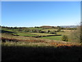
2
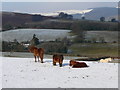
Fields south of Rudry
A clear contrast between the cultivated fields and the uncultivated Mynydd Rudry in the background.
Image: © John Light
Taken: 4 Aug 2011
0.14 miles
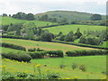
3
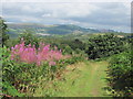
View towards Machen from Rudry Common
Taken from a pleasant footpath on the southern edge of the common.
Image: © John Light
Taken: 4 Aug 2011
0.18 miles
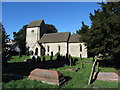
6
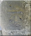
Ordnance Survey Cut Mark
This OS cut mark can be found on the SW face of St James the Great's Church. It marks a point 146.694m above mean sea level.
Image: © Adrian Dust
Taken: 1 Aug 2019
0.23 miles