IMAGES TAKEN NEAR TO
Porset Row, CAERPHILLY, CF83 3BJ
Introduction
This page details the photographs taken nearby to Porset Row, CF83 3BJ by members of the Geograph project.
The Geograph project started in 2005 with the aim of publishing, organising and preserving representative images for every square kilometre of Great Britain, Ireland and the Isle of Man.

There are currently over 7.5m images from over14,400 individuals and you can help contribute to the project by visiting https://www.geograph.org.uk
Image Map
Images are licensed for reuse under creativecommons.org/licenses/by-sa/2.0
Notes
- Clicking on the map will re-center to the selected point.
- The higher the marker number, the further away the image location is from the centre of the postcode.
Image Listing (81 Images Found)
Images are licensed for reuse under creativecommons.org/licenses/by-sa/2.0
Image
Details
Distance
1
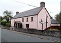
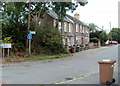
Porset Farm, Caerphilly
The name on the cottage is Porset Farm, but there is no farming nearby in 2011. Trees occupy most of the land behind the house, up to the south bank of the River Rhymney, about 70 metres away.
Image: © Jaggery
Taken: 17 Aug 2011
0.02 miles
2
Bricked fork in the road, Old Bedwas Road, Caerphilly
The tarmacked road surface is replaced by a bricked surface for a few metres at the junction of Old Bedwas Road and Rudry Road, in the NE of Caerphilly.
The grubby signs show ½ mile to Bedwas on the left, and Rudry 2½ miles away on the right. The white single-storey building is part of Porset Farm Cottages. http://www.geograph.org.uk/photo/2558155
Image: © Jaggery
Taken: 17 Aug 2011
0.05 miles
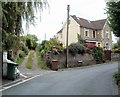
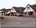
3
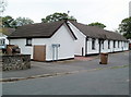
Porset Farm Cottages, Caerphilly
The long, single-storey building is divided into two properties, located on Old Bedwas Road at the Rudry Road junction. Out of shot on the left is the house named Porset Farm. http://www.geograph.org.uk/photo/2558017
Image: © Jaggery
Taken: 17 Aug 2011
0.05 miles
4
Porset Row, Caerphilly
A named row of houses on the south side of Old Bedwas Road. Porset Farm http://www.geograph.org.uk/photo/2558017 is nearby, on the opposite side of the road.
Image: © Jaggery
Taken: 17 Aug 2011
0.05 miles
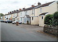
5
A row of three houses, Old Bedwas Road, Caerphilly
The houses are near the Rudry junction and face Porset Farm. http://www.geograph.org.uk/photo/2558017
Image: © Jaggery
Taken: 17 Aug 2011
0.05 miles
6
West View or Westview Terrace, Rudry Road, Caerphilly
The street name sign disagrees with maps I've consulted (not an unprecedented occurrence!). The sign, to the right of the pole, shows West View, whereas two maps show the track on the left as Westview Terrace.
Image: © Jaggery
Taken: 17 Aug 2011
0.06 miles
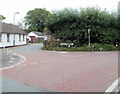
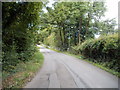
7
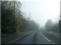
Unnamed ring road between Caerphilly and Bedwas
Image: © Colin Pyle
Taken: 17 Dec 2013
0.08 miles
8
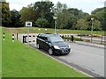
Ignore satnav in this Bedwas car park
The sign shows a big red cross through a van or lorry. The text on the sign is
Ignore satellite navigation systems.
One wonders what satnav-induced incident(s) occurred in this car park to cause the sign to be erected here, on the south side of Bedwas Road (A468).
Image: © Jaggery
Taken: 13 Aug 2011
0.08 miles
9
Tollgate Close, Caerphilly
Houses on the north side of Tollgate Close viewed from the corner of Old Bedwas Road.
Image: © Jaggery
Taken: 17 Aug 2011
0.08 miles
10
Old Bedwas Road, Caerphilly
A view to the SW from near the Fishermans Rest pub. http://www.geograph.org.uk/photo/2557798
Image: © Jaggery
Taken: 17 Aug 2011
0.11 miles