IMAGES TAKEN NEAR TO
Rhodfa'r Rhyddwen, CAERPHILLY, CF83 2WB
Introduction
This page details the photographs taken nearby to Rhodfa'r Rhyddwen, CF83 2WB by members of the Geograph project.
The Geograph project started in 2005 with the aim of publishing, organising and preserving representative images for every square kilometre of Great Britain, Ireland and the Isle of Man.

There are currently over 7.5m images from over14,400 individuals and you can help contribute to the project by visiting https://www.geograph.org.uk
Image Map
Images are licensed for reuse under creativecommons.org/licenses/by-sa/2.0
Notes
- Clicking on the map will re-center to the selected point.
- The higher the marker number, the further away the image location is from the centre of the postcode.
Image Listing (3 Images Found)
Images are licensed for reuse under creativecommons.org/licenses/by-sa/2.0
Image
Details
Distance
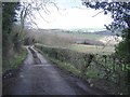
2

Nant-yr-Aber valley near Penyrheol, Caerphilly
A view to the SW from the B4263 into the valley of a stream, Nant-yr-Aber.
Image: © Jaggery
Taken: 1 May 2012
0.21 miles
3
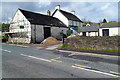
Ty Isaf Farm buildings, Penyrheol, Caerphilly
Viewed across the B4263, the road to Abertridwr and Senghenydd.
Image: © Jaggery
Taken: 1 May 2012
0.22 miles