IMAGES TAKEN NEAR TO
Station Terrace, CAERPHILLY, CF83 2RH
Introduction
This page details the photographs taken nearby to Station Terrace, CF83 2RH by members of the Geograph project.
The Geograph project started in 2005 with the aim of publishing, organising and preserving representative images for every square kilometre of Great Britain, Ireland and the Isle of Man.

There are currently over 7.5m images from over14,400 individuals and you can help contribute to the project by visiting https://www.geograph.org.uk
Image Map
Images are licensed for reuse under creativecommons.org/licenses/by-sa/2.0
Notes
- Clicking on the map will re-center to the selected point.
- The higher the marker number, the further away the image location is from the centre of the postcode.
Image Listing (54 Images Found)
Images are licensed for reuse under creativecommons.org/licenses/by-sa/2.0
Image
Details
Distance
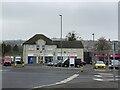
1
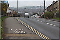
Station Terrace, B4263, Penyrheol
The grooved paving stones mark where National Cycle Route 475 leaves the road and turns left on to the Aber Cycleway Image
Image: © M J Roscoe
Taken: 11 Apr 2018
0.03 miles
2
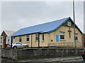
Bethel Baptist Church
Baptist Church in Abertridwr.
Image: © Alan Hughes
Taken: 4 Mar 2021
0.03 miles
3
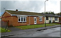
Ty-isaf Bungalows, Caerphilly
Viewed from Station Terrace, at the edge of the Penyrheol district of Caerphilly. The street name sign (out of shot) shows Ty-isaf Bungalows. Seen here are 2 of the 26 bungalows in the street.
Image: © Jaggery
Taken: 1 May 2012
0.04 miles
4
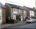
Hank Marvin, Caerphilly
Located at 10 Station Terrace near the Penyrheol district of Caerphilly. Formerly occupied by Lynn's Mighty Bites, the shop is now Hank Marvin takeaway, opened in April 2012. A sign on the pavement shows Freshly Made Hot & Cold Food.
The connection, if any, with Hank Marvin the lead guitarist of The Shadows is not known by this contributor.
Image: © Jaggery
Taken: 1 May 2012
0.04 miles
5
Former Bowls Inn to let, Caerphilly
Located in Bowls Close, at the edge of the Penyrheol district of Caerphilly,
the former pub is boarded up and to let. This http://www.geograph.org.uk/photo/376534 is how it looked when open.
Image: © Jaggery
Taken: 1 May 2012
0.04 miles
6
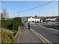
Cylchdro Penyrheol Roundabout
Yn agosau at gylchdro Penyrheol.
Approaching the roundabout at Penyrheol (top of the road)
Image: © Alan Richards
Taken: 30 Mar 2014
0.04 miles
7
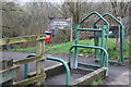
Aber Cycleway at Station Terrace, Penyrheol
The Cycleway (NCR 475) comes up from the former railway track bed (far left) to the road, B4263; NCR 475 continues down the road behind the camera. Formerly the railway ran underneath the road. One of the metal plates on the stile appears to be missing.
Image: © M J Roscoe
Taken: 11 Apr 2018
0.05 miles
8
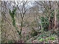
Rhymney Railway branch line
Through the dense woodland overgrowth the line of the old Rhymney Valley railway, now a cycle track, is just visible. It followed Nant yr Aber from Senghennydd, through Abertridwr, to Caerphilly..
Image: © Alan Hughes
Taken: 4 Mar 2021
0.06 miles
10

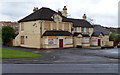
The Bowls Inn Pub Caerphilly
Nice picture taken on a Sunny Day, alas the Pub is no longer going and has been closed down
Image: © Eddie Reed
Taken: 13 Feb 2010
0.07 miles