IMAGES TAKEN NEAR TO
Moel Fryn, CAERPHILLY, CF83 2BU
Introduction
This page details the photographs taken nearby to Moel Fryn, CF83 2BU by members of the Geograph project.
The Geograph project started in 2005 with the aim of publishing, organising and preserving representative images for every square kilometre of Great Britain, Ireland and the Isle of Man.

There are currently over 7.5m images from over14,400 individuals and you can help contribute to the project by visiting https://www.geograph.org.uk
Image Map
Images are licensed for reuse under creativecommons.org/licenses/by-sa/2.0
Notes
- Clicking on the map will re-center to the selected point.
- The higher the marker number, the further away the image location is from the centre of the postcode.
Image Listing (20 Images Found)
Images are licensed for reuse under creativecommons.org/licenses/by-sa/2.0
Image
Details
Distance
1
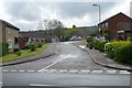
Moel Fryn, Penyrheol,Caerphilly
Moel Fryn is a short residential cul-de-sac in the Penyrheol district of Caerphilly.
Viewed across Caledfryn Way.
Image: © Jaggery
Taken: 1 May 2012
0.08 miles
2
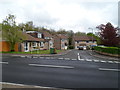
Bryn Ifor, Caerphilly
Viewed across Caledfryn Way, Penyrheol. Bryn Ifor is a cul-de-sac of 7 houses.
Image: © Jaggery
Taken: 1 May 2012
0.09 miles
3
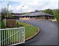
Caerphilly Family Centre
Caerphilly County Borough Council premises, Caledfryn Way, Penyrheol.
Image: © Jaggery
Taken: 1 May 2012
0.09 miles
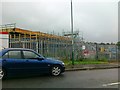
5
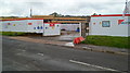
Replacement school building site, Penyrheol, Caerphilly
This is the Cwm Ifor Primary School replacement project, viewed across Caledfryn Way. The main contractor is Kier Western. Work began here, on the SW side of the existing school buildings, in autumn 2011. The £6 million project is being two-thirds funded by the Welsh Government, with Caerphilly County Borough Council funding the remainder. The current Cwm Ifor Primary School building was built in the 1950s. It occupies a scattered site, with an end-to-end distance of more than 200 metres. The more compact replacement school is scheduled to open in September 2012.
Image: © Jaggery
Taken: 1 May 2012
0.14 miles
6
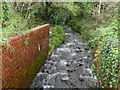
Stream flows towards Heol Aneurin, Penyrheol, Caerphilly
Near the corner of Caledfryn Way, an unnamed stream flows towards the camera and a conduit under the road.
Image: © Jaggery
Taken: 1 May 2012
0.18 miles
7
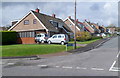
Bryn Siriol, Caerphilly
Houses on the west side of Bryn Siriol viewed from the B4263.
Image: © Jaggery
Taken: 1 May 2012
0.20 miles
8
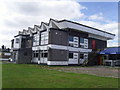
Aneurin Social Club, Penyrheol
Image: © Duncan and Gareth Alderson
Taken: 28 Aug 2007
0.20 miles
9
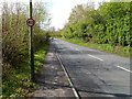
Rural section of the B4263 SE of Abertridwr
This is part of a 700-metre long stretch of the B4263 between Penyrheol and Abertridwr that uses a narrow shelf through sloping land in the Nant-yr-Aber valley. Adjacent to the road, there is no land flat enough for houses.
Image: © Jaggery
Taken: 1 May 2012
0.20 miles
10
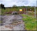
Demolition site near Penyrheol ACF hall, Caerphilly
The fenced-off site is on the north side of the B4263 near an ACF hall. http://www.geograph.org.uk/photo/2931290
Image: © Jaggery
Taken: 1 May 2012
0.20 miles