IMAGES TAKEN NEAR TO
Crescent Road, CAERPHILLY, CF83 1XX
Introduction
This page details the photographs taken nearby to Crescent Road, CF83 1XX by members of the Geograph project.
The Geograph project started in 2005 with the aim of publishing, organising and preserving representative images for every square kilometre of Great Britain, Ireland and the Isle of Man.

There are currently over 7.5m images from over14,400 individuals and you can help contribute to the project by visiting https://www.geograph.org.uk
Image Map
Images are licensed for reuse under creativecommons.org/licenses/by-sa/2.0
Notes
- Clicking on the map will re-center to the selected point.
- The higher the marker number, the further away the image location is from the centre of the postcode.
Image Listing (598 Images Found)
Images are licensed for reuse under creativecommons.org/licenses/by-sa/2.0
Image
Details
Distance
2
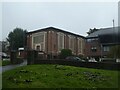
Claude Road side of Wesley Methodist Church, Caerphilly
The church on the corner of Crescent Road and Claude Road opened for worship in 1930. In 2019 the church is part of the North Cluster of the Cardiff Methodist Circuit. The building was Grade II listed in 1999.
Image: © Jaggery
Taken: 8 Jan 2019
0.03 miles
3
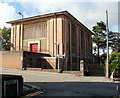
Wesley Methodist Church, Caerphilly
The church, on the corner of Crescent Road and Claude Road, opened for worship in 1930. It was Grade II listed in February 1999.
Image: © Jaggery
Taken: 25 Aug 2011
0.03 miles
4
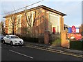
Elim Pentecostal Church, Caerphilly
Located on Crescent Road, opposite Wesley Methodist Church. http://www.geograph.org.uk/photo/2570117
The northern and southern perimeters of the church site are along Park Lane and St Fagans Street.
Image: © Jaggery
Taken: 25 Aug 2011
0.03 miles
5
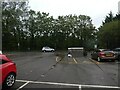
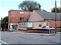
Car park off Crescent Road, Caerphilly with damaged bin
The leftmost bin has been hit by a vehicle (with some force!)
Image: © David Smith
Taken: 30 Sep 2021
0.03 miles
6
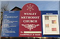
Wesley Methodist Church information board, Caerphilly
On display on the right here https://www.geograph.org.uk/photo/6042027 in January 2019.
Image: © Jaggery
Taken: 8 Jan 2019
0.03 miles
7
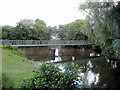
Footbridge, Caerphilly Castle moat
The left side of the footbridge connects with Crescent Road, at the SW edge of the castle moat.
Image: © Jaggery
Taken: 25 Aug 2011
0.04 miles
8
Wires over a Caerphilly corner
Wires radiate from a wooden pole on the corner of Crescent Road and St Fagans Street.
Image: © Jaggery
Taken: 8 Jan 2019
0.04 miles
9
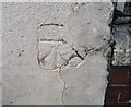
Ordnance Survey Cut Mark
This OS cut mark can be found on No53 Ludlow Street. It marks a point 96.174m above mean sea level.
Image: © Adrian Dust
Taken: 20 Jul 2018
0.04 miles
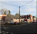
10
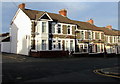
Row of houses, Ludlow Street, Caerphilly
This part of Ludlow Street is between Florence Grove and Claude Road.
Image: © Jaggery
Taken: 8 Jan 2019
0.04 miles