1
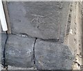
Ordnance Survey Cut Mark
This OS cut mark can be found on the Baptist Chapel, Bedwas Road. It marks a point 77.200m above mean sea level.
Image: © Adrian Dust
Taken: 20 Jul 2018
0.02 miles
2
Ton-y-felin Road
Image: © Des Blenkinsopp
Taken: 20 Feb 2014
0.02 miles
3
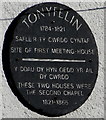
Tonyfelin plaque, Caerphilly
On the wall here. https://www.geograph.org.uk/photo/6026473 The text is in Welsh and English.
Image: © Jaggery
Taken: 17 Jan 2019
0.02 miles
4
Lloyds Pharmacy and Clear Sky Recruitment, 31 Ton-y-felin Rd, Caerphilly
Lloyds Pharmacy on the ground floor, Clear Sky Recruitment office on the first floor.
Image: © Jaggery
Taken: 21 Jun 2018
0.03 miles
5
Tonyfelin Welsh Baptist Chapel, Caerphilly
Located on Bedwas Road. The chapel was built in 1800 and rebuilt/modified in 1820.
Image: © Jaggery
Taken: 21 Apr 2010
0.03 miles
6
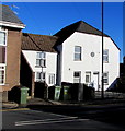
White houses, Tonyfelin Road, Caerphilly
The round plaque https://www.geograph.org.uk/photo/6026476 on the wall records the site of the first Tonyfelin Meeting House (1784-1821).
The two houses were the second chapel (1821-1866).
Image: © Jaggery
Taken: 17 Jan 2019
0.03 miles
7
Entrance to Clear Sky Recruitment office, Bedwas Road, Caerphilly
The building https://www.geograph.org.uk/photo/5815766 is on the corner of Bedwas Road and Ton-y-felin Road.
Clear Sky Recruitment office is on the first floor. Lloyds Pharmacy is on the ground floor.
Image: © Jaggery
Taken: 21 Jun 2018
0.04 miles
8
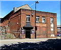
Workmen's Workout
A gym is now in the old workmen's hall and institute.
Image: © Des Blenkinsopp
Taken: 20 Feb 2014
0.05 miles
9
Ton-y-felin Road houses, Caerphilly
Houses on the north side of the B4600 Ton-y-felin Road viewed from the corner of Bedwas Road.
Image: © Jaggery
Taken: 21 Jun 2018
0.06 miles
10
Mean Muscle Gymnasium, Bedwas Road, Caerphilly
The Bedwas Road side of the gym at 20 Castle Street. The name embossed on the building is Caerphilly Workmen's Hall & Institute which was officially opened on February 7th 1925, Grade II listed in 1995.
Image: © Jaggery
Taken: 21 Jun 2018
0.06 miles


