1
The Twyn School, Caerphilly
Image: © John Lord
Taken: 6 Jan 2010
0.01 miles
2
Ordnance Survey Cut Mark
This OS cut mark can be found on the west face of the school. It marks a point 86.636m above mean sea level.
Image: © Adrian Dust
Taken: 20 Jul 2018
0.04 miles
3
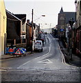
Down Southern Street, Caerphilly
Southern Street descends from Van Road.
Image: © Jaggery
Taken: 3 Oct 2014
0.04 miles
4
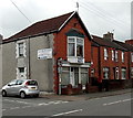
Vacant Van Road shop, Caerphilly
In early October 2014, there is a LET BY board on the shop at 26 Van Road. A Google Earth Street View taken in August 2011 shows the shop was occupied by Lucky 7 Tattoo, now in Windsor Street. http://www.geograph.org.uk/photo/4191053
Image: © Jaggery
Taken: 3 Oct 2014
0.05 miles
5
East along Van Road, Caerphilly
Towards Van Road United Reformed Church. https://www.geograph.org.uk/photo/2560461
Image: © Jaggery
Taken: 17 Dec 2018
0.05 miles
6
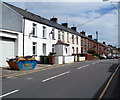
Van Road houses, Caerphilly
Van Road heads east away from the town centre, towards the district of Van at the eastern edge of Caerphilly.
Image: © Jaggery
Taken: 19 Aug 2011
0.05 miles
7
Southern end of Southern Street, Caerphilly
Viewed across Van Road. A 20mph speed limit applies along Southern Street on the approach
to The Twyn School. http://www.geograph.org.uk/photo/1650319 The small blue signs with white arrows indicate one-way traffic,
away from the camera.
Image: © Jaggery
Taken: 3 Oct 2014
0.06 miles
8
Van Road houses, Caerphilly
Looking east along Van Road towards the Southern Street junction.
Image: © Jaggery
Taken: 3 Oct 2014
0.06 miles
9
Ordnance Survey Cut Mark
This OS cut mark can be found on No68 Van Road. It marks a point 95.994m above mean sea level.
Image: © Adrian Dust
Taken: 20 Jul 2018
0.06 miles
10
Williams Television repairs shop, Caerphilly
An arrow on the wall of 55 Van Road points left towards the workshop. http://www.geograph.org.uk/photo/4191311
Image: © Jaggery
Taken: 3 Oct 2014
0.06 miles


