IMAGES TAKEN NEAR TO
Cwrt Nant Y Felin, CAERPHILLY, CF83 1TP
Introduction
This page details the photographs taken nearby to Cwrt Nant Y Felin, CF83 1TP by members of the Geograph project.
The Geograph project started in 2005 with the aim of publishing, organising and preserving representative images for every square kilometre of Great Britain, Ireland and the Isle of Man.

There are currently over 7.5m images from over14,400 individuals and you can help contribute to the project by visiting https://www.geograph.org.uk
Image Map
Images are licensed for reuse under creativecommons.org/licenses/by-sa/2.0
Notes
- Clicking on the map will re-center to the selected point.
- The higher the marker number, the further away the image location is from the centre of the postcode.
Image Listing (10 Images Found)
Images are licensed for reuse under creativecommons.org/licenses/by-sa/2.0
Image
Details
Distance
1
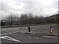
A469
At the junction of Blackbrook Road.
Image: © Burgess Von Thunen
Taken: 25 Jan 2012
0.12 miles
2
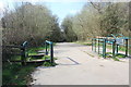
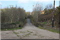
Celtic Trail from old Watford Road, Caerphilly
NCR 4 descends to a dismantled railway line.
Image: © M J Roscoe
Taken: 28 Mar 2019
0.13 miles
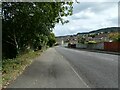
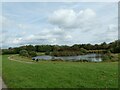
4
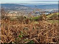
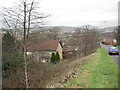
Watford Park
View over bracken from Craig yr Allt towards Watford Park, Caerphilly.
Image: © Alan Hughes
Taken: 3 Dec 2019
0.13 miles
5
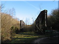
Bridge over Penrhos Cutting, Caerphilly
Former road bridge carrying the Rhymney Valley Ridgeway Walk over a former railway track bed.
Image: © M J Roscoe
Taken: 28 Mar 2019
0.13 miles
6
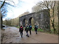
Olion pont reilffordd / remains of railway bridge
Cerddwyr yn agosau at olion pont rheilffordd. Cysyllatai'r lein bentref glofaol Aber a Ffynnon Taf.
Walkers approaching the remains of a railway bridge. The line linked the mining village of Aber with Taffs Well.
Image: © Alan Richards
Taken: 23 Mar 2014
0.18 miles
7
Bridge abutments at former Penrhos Upper Junction
The Celtic Trail on the trackbed of the former Taff's Well to Aber line comes to the site of Penrhos Upper Junction. At this point three railway lines converged from the south/west and another passed overhead. The Celtic trail now does a dog-leg to the right and continues on towards Caerphilly via a housing estate.
Image: © Gareth James
Taken: 21 Feb 2009
0.20 miles
8
Watford Park
Houses off Ffordd Traws Cwm.
Image: © Burgess Von Thunen
Taken: 25 Jan 2012
0.21 miles
10
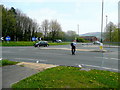
Crossing the A468
This fellow is taking care at the Penrhos Roundabout at Caerphilly.
Image: © Jonathan Billinger
Taken: 26 Apr 2010
0.25 miles