IMAGES TAKEN NEAR TO
Beech Close, CAERPHILLY, CF83 1SF
Introduction
This page details the photographs taken nearby to Beech Close, CF83 1SF by members of the Geograph project.
The Geograph project started in 2005 with the aim of publishing, organising and preserving representative images for every square kilometre of Great Britain, Ireland and the Isle of Man.

There are currently over 7.5m images from over14,400 individuals and you can help contribute to the project by visiting https://www.geograph.org.uk
Image Map
Images are licensed for reuse under creativecommons.org/licenses/by-sa/2.0
Notes
- Clicking on the map will re-center to the selected point.
- The higher the marker number, the further away the image location is from the centre of the postcode.
Image Listing (9 Images Found)
Images are licensed for reuse under creativecommons.org/licenses/by-sa/2.0
Image
Details
Distance
3
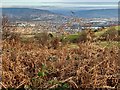
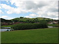
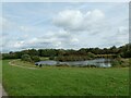
Watford Park
View over bracken from Craig yr Allt towards Watford Park, Caerphilly.
Image: © Alan Hughes
Taken: 3 Dec 2019
0.15 miles
4
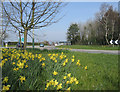
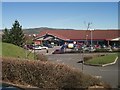
Penrhos Roundabout ,Caerphilly
Penrhos roundabout in the spring, at the top of Nantgarw hill on the busy A468.
Image: © Peter Wasp
Taken: 24 Mar 2007
0.20 miles
6
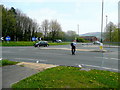
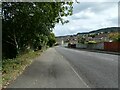
Crossing the A468
This fellow is taking care at the Penrhos Roundabout at Caerphilly.
Image: © Jonathan Billinger
Taken: 26 Apr 2010
0.21 miles
7
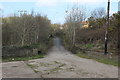
Bridge over Penrhos Cutting, Caerphilly
Former road bridge carrying the Rhymney Valley Ridgeway Walk over a former railway track bed.
Image: © M J Roscoe
Taken: 28 Mar 2019
0.22 miles
8
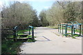
Celtic Trail from old Watford Road, Caerphilly
NCR 4 descends to a dismantled railway line.
Image: © M J Roscoe
Taken: 28 Mar 2019
0.23 miles