
IMAGES TAKEN NEAR TO
Van Road, CAERPHILLY, CF83 1LB
Introduction
This page details the photographs taken nearby to Van Road, CF83 1LB by members of the Geograph project.
The Geograph project started in 2005 with the aim of publishing, organising and preserving representative images for every square kilometre of Great Britain, Ireland and the Isle of Man.

There are currently over 7.5m images from over14,400 individuals and you can help contribute to the project by visiting https://www.geograph.org.uk
Image Map
Images are licensed for reuse under creativecommons.org/licenses/by-sa/2.0
Notes
- Clicking on the map will re-center to the selected point.
- The higher the marker number, the further away the image location is from the centre of the postcode.
Image Listing (792 Images Found)
Images are licensed for reuse under creativecommons.org/licenses/by-sa/2.0
Image
Details
Distance
1
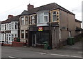
Vacant Van Road shop, Caerphilly
In early October 2014, there is a LET BY board on the shop at 26 Van Road. A Google Earth Street View taken in August 2011 shows the shop was occupied by Lucky 7 Tattoo, now in Windsor Street. http://www.geograph.org.uk/photo/4191053
Image: © Jaggery
Taken: 3 Oct 2014
0.02 miles
2
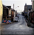
East along Van Road, Caerphilly
Towards Van Road United Reformed Church. https://www.geograph.org.uk/photo/2560461
Image: © Jaggery
Taken: 17 Dec 2018
0.02 miles
3
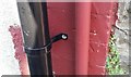
Ordnance Survey Cut Mark
This OS cut mark can be found on No21 Van Road. It marks a point 93.598m above mean sea level.
Image: © Adrian Dust
Taken: 20 Jul 2018
0.03 miles
4
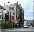
Van Road United Reformed Church Caerphilly viewed from the east
Restoration work on the church building began in 2008 and is currently (2011) ongoing, in phases as funding becomes available. The church building is also used by the Vanguard Centre, (established in 2003) a secular organisation whose aim is to provide facilities for community activities.
http://www.geograph.org.uk/photo/2560461 to another view.
Image: © Jaggery
Taken: 19 Aug 2011
0.04 miles
5
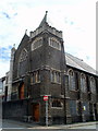
Van Road United Reformed Church Caerphilly viewed from the west
This view is of the corner of Van Road and Goodrich Street. http://www.geograph.org.uk/photo/2560456 to another view.
Restoration work on the church building began in 2008 and is currently (2011) ongoing, in phases as funding becomes available. The church building is also used by the Vanguard Centre, (established in 2003) a secular organisation whose aim is to provide facilities for community activities.
Image: © Jaggery
Taken: 19 Aug 2011
0.04 miles
7
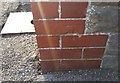
Ordnance Survey Cut Mark
This OS cut mark can be found on the west face of the school. It marks a point 86.636m above mean sea level.
Image: © Adrian Dust
Taken: 20 Jul 2018
0.04 miles
8
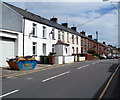
Van Road houses, Caerphilly
Van Road heads east away from the town centre, towards the district of Van at the eastern edge of Caerphilly.
Image: © Jaggery
Taken: 19 Aug 2011
0.04 miles
9
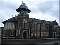
Caerphilly
Towering municipal building in the centre of Caerphilly.
www.visitcaerphilly.com
Image: © Colin Smith
Taken: 3 Apr 2011
0.05 miles
10
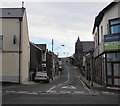
Van Road, Caerphilly
East along Van Road towards the Van area of Caerphilly.
Van Road United Reformed Church https://www.geograph.org.uk/photo/2560461 is in the background.
Image: © Jaggery
Taken: 8 Jan 2019
0.05 miles