IMAGES TAKEN NEAR TO
Meadow Crescent, CAERPHILLY, CF83 1JX
Introduction
This page details the photographs taken nearby to Meadow Crescent, CF83 1JX by members of the Geograph project.
The Geograph project started in 2005 with the aim of publishing, organising and preserving representative images for every square kilometre of Great Britain, Ireland and the Isle of Man.

There are currently over 7.5m images from over14,400 individuals and you can help contribute to the project by visiting https://www.geograph.org.uk
Image Map
Images are licensed for reuse under creativecommons.org/licenses/by-sa/2.0
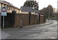
Notes
- Clicking on the map will re-center to the selected point.
- The higher the marker number, the further away the image location is from the centre of the postcode.
Image Listing (407 Images Found)
Images are licensed for reuse under creativecommons.org/licenses/by-sa/2.0
Image
Details
Distance
1
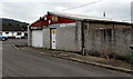
Williams Television repairs workshop, Caerphilly
On the corner of Maes Gwyn, a few metres south of the shop. http://www.geograph.org.uk/photo/4191310
Image: © Jaggery
Taken: 3 Oct 2014
0.05 miles
2
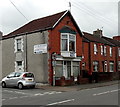
Williams Television repairs shop, Caerphilly
An arrow on the wall of 55 Van Road points left towards the workshop. http://www.geograph.org.uk/photo/4191311
Image: © Jaggery
Taken: 3 Oct 2014
0.06 miles
3
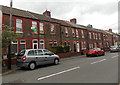
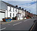
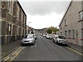
Van Road houses, Caerphilly
Looking east along Van Road towards the Southern Street junction.
Image: © Jaggery
Taken: 3 Oct 2014
0.07 miles
4
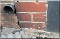
Ordnance Survey Cut Mark
This OS cut mark can be found on No68 Van Road. It marks a point 95.994m above mean sea level.
Image: © Adrian Dust
Taken: 20 Jul 2018
0.07 miles
5
Van Road houses, Caerphilly
Van Road heads east away from the town centre, towards the district of Van at the eastern edge of Caerphilly.
Image: © Jaggery
Taken: 19 Aug 2011
0.07 miles
6
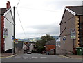
Southern end of Southern Street, Caerphilly
Viewed across Van Road. A 20mph speed limit applies along Southern Street on the approach
to The Twyn School. http://www.geograph.org.uk/photo/1650319 The small blue signs with white arrows indicate one-way traffic,
away from the camera.
Image: © Jaggery
Taken: 3 Oct 2014
0.07 miles
7
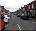
East along Bartlett Street, Caerphilly
From the corner of White Street.
Image: © Jaggery
Taken: 3 Oct 2014
0.08 miles
8
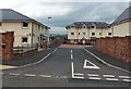
Heol Awstin, Caerphilly
Housing association dwellings on the eastern approach to Caerphilly Park & Ride (car park, railway station and bus station).
Image: © Jaggery
Taken: 3 Oct 2014
0.09 miles
9
Warning sign - humps for 200 yards, Station Terrace Car Park, Caerphilly
At the eastern end of the car park. The text is also in Welsh.
Image: © Jaggery
Taken: 22 Dec 2018
0.10 miles
10
Goodrich Street, Caerphilly
Looking south from Van Road. Van Road United Reformed Church http://www.geograph.org.uk/photo/2560461 is on the left.
Image: © Jaggery
Taken: 3 Oct 2014
0.10 miles