IMAGES TAKEN NEAR TO
Austin Road, CAERPHILLY, CF83 1GR
Introduction
This page details the photographs taken nearby to Austin Road, CF83 1GR by members of the Geograph project.
The Geograph project started in 2005 with the aim of publishing, organising and preserving representative images for every square kilometre of Great Britain, Ireland and the Isle of Man.

There are currently over 7.5m images from over14,400 individuals and you can help contribute to the project by visiting https://www.geograph.org.uk
Image Map
Images are licensed for reuse under creativecommons.org/licenses/by-sa/2.0
Notes
- Clicking on the map will re-center to the selected point.
- The higher the marker number, the further away the image location is from the centre of the postcode.
Image Listing (318 Images Found)
Images are licensed for reuse under creativecommons.org/licenses/by-sa/2.0
Image
Details
Distance
1
Warning sign - humps for 200 yards, Station Terrace Car Park, Caerphilly
At the eastern end of the car park. The text is also in Welsh.
Image: © Jaggery
Taken: 22 Dec 2018
0.02 miles
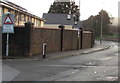
2
Heol Awstin, Caerphilly
Housing association dwellings on the eastern approach to Caerphilly Park & Ride (car park, railway station and bus station).
Image: © Jaggery
Taken: 3 Oct 2014
0.02 miles
3
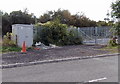
DNO electricity cubicle near Caerphilly railway station
Located about 100 metres east of Caerphilly railway station. DNO is Distribution Network Operator.
The cubicle enables Network Rail to connect to the local electricity
grid for low voltage power to operate various items of railway equipment.
Image: © Jaggery
Taken: 3 Oct 2014
0.02 miles
4
Lineside cabinets near Caerphilly railway station
Located about 300 metres east of Caerphilly railway station.
Railway Terrace houses are in the background.
Image: © Jaggery
Taken: 22 Dec 2018
0.03 miles
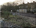
5
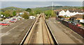
The view east from Caerphilly Railway Station
In the middle distance is a crossover connecting the two tracks.
Ahead, out of view, the track curves to the southeast into Caerphilly Tunnel, on the way to the northern suburbs of Cardiff.
Image: © Jaggery
Taken: 7 May 2010
0.05 miles
6
A view from the east end of platform 2, Caerphilly railway station
In the middle distance is a crossover connecting the two tracks. Ahead, out of view, the track curves to the southeast into Caerphilly Tunnel, on the way to the northern suburbs of Cardiff. The next station is this direction is Lisvane & Thornhill.
Image: © Jaggery
Taken: 27 Apr 2012
0.05 miles
7
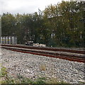
Lineside boxes east of Caerphilly railway station
Viewed from a roadside fence. This is part of the Rhymney Line of the Valley Lines network. Caerphilly railway station is about 350 metres beyond the right edge of the photo. Beyond the left edge of the photo, about 1500 metres away on the route to Cardiff, is the 1.77km (1.1 mile) long Caerphilly Tunnel.
Image: © Jaggery
Taken: 3 Oct 2014
0.06 miles
8
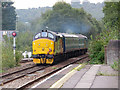
Class 37 at Caerphilly
Class 37 No. 37421 tails the 07:24 Rhymney to Cardiff Central service at Caerphilly. This service is currently running with only three carriages (instead of the usual four), causing some overcrowding for commuters. Sister locomotive No. 37025 is leading.
Image: © Gareth James
Taken: 6 Sep 2019
0.06 miles
9
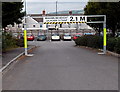
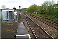
Height barrier in Caerphilly Park & Ride car park
The metal barrier enforces a 2.1m maximum vehicle height. Caerphilly Park & Ride
car park is on the east side of Caerphilly railway station and bus station.
Image: © Jaggery
Taken: 3 Oct 2014
0.07 miles
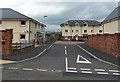
10
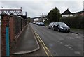
King Edward Avenue, Caerphilly
Looking east along King Edward Avenue towards Princess Avenue and Railway Terrace.
The perimeter wall of Caerphilly railway station and a footbridge are on the left.
Image: © Jaggery
Taken: 5 Apr 2019
0.08 miles