IMAGES TAKEN NEAR TO
Claude Road, CAERPHILLY, CF83 1GP
Introduction
This page details the photographs taken nearby to Claude Road, CF83 1GP by members of the Geograph project.
The Geograph project started in 2005 with the aim of publishing, organising and preserving representative images for every square kilometre of Great Britain, Ireland and the Isle of Man.

There are currently over 7.5m images from over14,400 individuals and you can help contribute to the project by visiting https://www.geograph.org.uk
Image Map
Images are licensed for reuse under creativecommons.org/licenses/by-sa/2.0
Notes
- Clicking on the map will re-center to the selected point.
- The higher the marker number, the further away the image location is from the centre of the postcode.
Image Listing (269 Images Found)
Images are licensed for reuse under creativecommons.org/licenses/by-sa/2.0
Image
Details
Distance
1
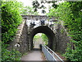
Railway bridge, Caerphilly
Footpath and National Cycle Network route 4 pass beneath the Cardiff-Rhymney line near Caerphilly.
Image: © Gareth James
Taken: 30 May 2010
0.00 miles
2
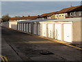
Long row of lockup garages, Florence Grove, Caerphilly
Extending for about 100 metres along the north side of Florence Grove.
Image: © Jaggery
Taken: 8 Jan 2019
0.05 miles
3
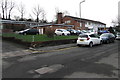
Castle View, Claude Road, Denscombe, Caerphilly
Castle View residential care home is owned by Caerphilly County Borough Council.
Image: © Jaggery
Taken: 10 Jan 2019
0.06 miles
4
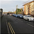
West along Claude Road, Caerphilly
From the corner of Ludlow Street. Wesley Methodist Church https://www.geograph.org.uk/photo/6042027 is on the right.
Image: © Jaggery
Taken: 8 Jan 2019
0.08 miles
5
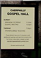
Information board outside Caerphilly Gospel Hall
On display here https://www.geograph.org.uk/photo/6030294 on January 10th 2019.
Image: © Jaggery
Taken: 10 Jan 2019
0.09 miles
6
Caerphilly Gospel Hall
On the north side of Claude Road near Ludlow Street in Caerphilly.
Image: © Jaggery
Taken: 10 Jan 2019
0.09 miles
7
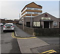
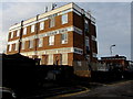
Caerphilly Exchange
Located between Claude Road and Florence Grove (ahead), Caerphilly Exchange provides broadband and telephone services for about 18,700 residential premises and 730 non-residential premises. The exchange identifier code is SWCAB.
Image: © Jaggery
Taken: 10 Jan 2019
0.09 miles
8
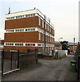
Florence Grove side of Caerphilly Exchange
Caerphilly Exchange provides broadband and telephone services for about 18,700 residential premises and 730 non-residential premises. The exchange identifier code is SWCAB.
Image: © Jaggery
Taken: 8 Jan 2019
0.09 miles
9
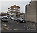
On-street parking, Claude Road, Caerphilly
The eastern end of Claude Road viewed across Ludlow Street from the corner of Pentrebane Street.
Image: © Jaggery
Taken: 10 Jan 2019
0.09 miles
10
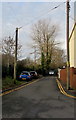
Western end of Rhymney Terrace, Caerphilly
West of the Ludlow Street junction.
Image: © Jaggery
Taken: 8 Jan 2019
0.10 miles