IMAGES TAKEN NEAR TO
St. Martins Road, CAERPHILLY, CF83 1EH
Introduction
This page details the photographs taken nearby to St. Martins Road, CF83 1EH by members of the Geograph project.
The Geograph project started in 2005 with the aim of publishing, organising and preserving representative images for every square kilometre of Great Britain, Ireland and the Isle of Man.

There are currently over 7.5m images from over14,400 individuals and you can help contribute to the project by visiting https://www.geograph.org.uk
Image Map
Images are licensed for reuse under creativecommons.org/licenses/by-sa/2.0
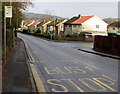
Notes
- Clicking on the map will re-center to the selected point.
- The higher the marker number, the further away the image location is from the centre of the postcode.
Image Listing (54 Images Found)
Images are licensed for reuse under creativecommons.org/licenses/by-sa/2.0
Image
Details
Distance
1
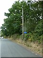
Sign for NCN4, St Christopher's Drive, Caerphilly
The sign also suggests it is a walking route
Image: © David Smith
Taken: 22 Sep 2022
0.03 miles
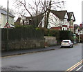
2
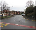
Western end of St Martin's Road, Caerphilly
Looking east from the northern end of Watford Road.
Image: © Jaggery
Taken: 11 Jan 2019
0.05 miles
3
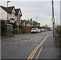
St Martin's Road bus stops, Caerphilly
The stop on the right is for buses to Caerphilly town centre and Caerphilly Interchange (bus station and railway station). In January 2019 the stop on the left is for buses on Route 25 to Cardiff and Route K to Caledfryn via Trecenydd.
Image: © Jaggery
Taken: 11 Jan 2019
0.06 miles
4
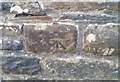
Ordnance Survey Cut Mark
This OS cut mark can be found on the wall of No102 St Martins Road. It marks a point 110.557m above mean sea level.
Image: © Adrian Dust
Taken: 20 Jul 2018
0.07 miles
5
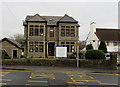
St Martin's House, St Martin's Road, Caerphilly
In January 2019 the nameboard shows St Martin's House - Abbeyfield Independent Living.
Image: © Jaggery
Taken: 11 Jan 2019
0.07 miles
6
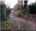
Path ascending from the south side of St Martin's Road, Caerphilly
Towards houses in Watford Rise.
Image: © Jaggery
Taken: 11 Jan 2019
0.07 miles
7
St Christopher's Drive, Caerphilly
The southwest end of St Christopher's Drive viewed across Lon-y-llyn.
Behind the camera, a National Cycle Network Route 4 direction sign https://www.geograph.org.uk/photo/6023106 points this way.
Image: © Jaggery
Taken: 11 Jan 2019
0.09 miles
8
Warning sign - elderly people, St Martin's Road, Caerphilly
Near the corner of St Martin's Crescent.
Image: © Jaggery
Taken: 11 Jan 2019
0.09 miles
9
Lon-y-llyn bus stop, Caerphilly
In January 2019 the bus stop sign shows Route K to Caledfryn.
Image: © Jaggery
Taken: 11 Jan 2019
0.09 miles
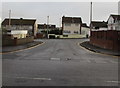
10
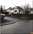
Junction of St Martin's Crescent and St Martin's Road, Caerphilly
St Martin's Crescent from the left joins St Martin's Road.
Image: © Jaggery
Taken: 11 Jan 2019
0.09 miles