IMAGES TAKEN NEAR TO
Greenhill Place, HENGOED, CF82 8EL
Introduction
This page details the photographs taken nearby to Greenhill Place, CF82 8EL by members of the Geograph project.
The Geograph project started in 2005 with the aim of publishing, organising and preserving representative images for every square kilometre of Great Britain, Ireland and the Isle of Man.

There are currently over 7.5m images from over14,400 individuals and you can help contribute to the project by visiting https://www.geograph.org.uk
Image Map
Images are licensed for reuse under creativecommons.org/licenses/by-sa/2.0
Notes
- Clicking on the map will re-center to the selected point.
- The higher the marker number, the further away the image location is from the centre of the postcode.
Image Listing (116 Images Found)
Images are licensed for reuse under creativecommons.org/licenses/by-sa/2.0
Image
Details
Distance
1
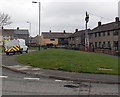
Man up a pole, Gelligaer
A Kelly Communications van is parked in Aneurin Bevan Avenue.
Nearby, a Kelly Communications engineer is working at the top of a telephone pole.
Image: © Jaggery
Taken: 10 May 2013
0.06 miles
2
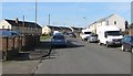
Heol Edward Lewis in Gelligaer
Looking to the WNW along Heol Edward Lewis towards the Greenhill Place junction.
Image: © Jaggery
Taken: 14 Feb 2019
0.07 miles
3
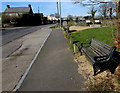
Roadside bench in Gelligaer
Alongside the B4254 Church Road.
Image: © Jaggery
Taken: 14 Feb 2019
0.11 miles
4
Roadside benches in Gelligaer
Alongside the B4254 Church Road on the approach to the Gelligaer Roman Fort site on the left.
Image: © Jaggery
Taken: 14 Feb 2019
0.11 miles
5
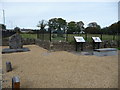
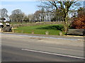
Part of Gelligaer Roman Fort remains
A few interpretation boards give an insight into the excavated fort site here.
The boulder is a monument to an early school which once stood on the site.
Image: © Jeremy Bolwell
Taken: 7 Oct 2012
0.11 miles
6
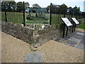
Interpretation at Gelligaer Roman Fort site
If you stand where indicated you can look through the panel and get an impression of what the fort looked like. The site was excavated in the early 20th century. It was one fort in a network of such forts and roads across South Wales.
Image: © Jeremy Bolwell
Taken: 7 Oct 2012
0.11 miles
7
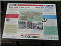
Interpretation board at Gelligaer
What lies beneath indeed? The site has been excavated and to be honest there is very little to see above ground or beneath now.
Image: © Jeremy Bolwell
Taken: 7 Oct 2012
0.11 miles
8
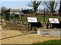
Information boards at the edge of the Gelligaer Roman Fort site
Facing Church Road.
Image: © Jaggery
Taken: 14 Feb 2019
0.11 miles
9
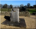
Stone on the site of the first Lewis School 1729, Gelligaer
The stone records https://www.geograph.org.uk/photo/6392431
ON THIS SITE STOOD THE FIRST LEWIS SCHOOL FOUNDED BY EDWARD LEWIS ESQ. 1729
Image: © Jaggery
Taken: 14 Feb 2019
0.11 miles
10
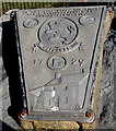
Inscription on the stone on the site of the first Lewis School 1729, Gelligaer
Located here. https://www.geograph.org.uk/photo/6392421 The text is
ON THIS SITE STOOD THE FIRST LEWIS SCHOOL FOUNDED BY EDWARD LEWIS ESQ. 1729
Image: © Jaggery
Taken: 14 Feb 2019
0.11 miles